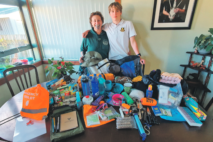
Whakatāne needs to prepare for a megathrust earthquake and resulting tsunami similar in size and strength to the 2011 Japan event, says local GNS researcher Mawera Karetai.
She has planned a series of workshops with GNS seismologists for next month as she feels most people in town are “woefully ill-prepared" for an earthquake.
Scientists studying the Hikurangi Subduction Zone, just off the east coast of the North Island, are predicting a major quake occurring in the next 50 years, with a one in four chance it could be as big as magnitude 9.1.
“When we have a magnitude 9 earthquake the roading network will fail completely. We have to prepare for infrastructure damage, liquefaction, fountaining fresh water from broken pipes and raw sewage,” she says
“This district will be completely isolated. All the resources will go to the cities.”
She referenced a 4.5 magnitude earthquake off Te Araroa on April 17, which, she said, “blew up on social media”.
“What we are predicted to have is 36,000 times stronger than that. We’re looking at, potentially, severe shaking for three to four minutes. There’s not much left standing at the end of that.”
People should not rely on the roading network to escape the resulting tsunami of up to 10 metres that could arrive within 25 minutes, she says.
“Also, be very mindful that our escarpment is rotten rock. It falls down if we get a rainstorm. So, we need to find multiple ways to get up the hill, not just relying on the road.”
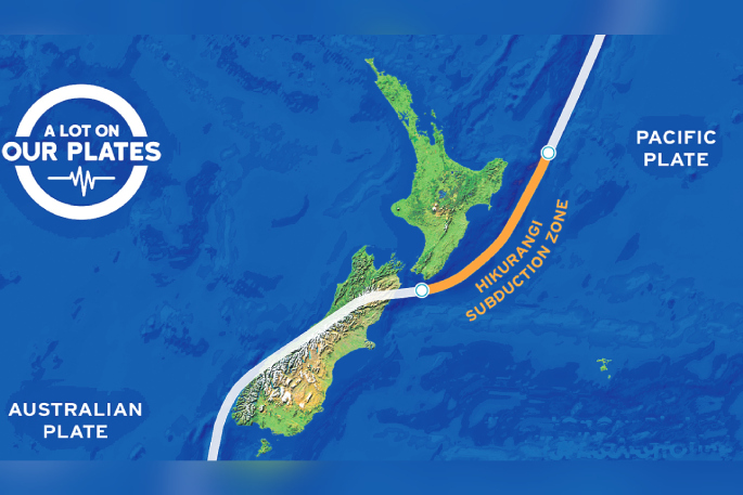 Plate shifts: The Hikurangi Subduction Zone is where the Pacific Plate dives beneath the Australian Plate on the east coast of the North Island. Image: East Coast Labs.
Dr Karetai has arranged for a series of four workshops in Whakatāne in the final week of June.
Te Whare Wānanga o Awanuiārangi will host the events, in collaboration with GNS Science and Whakatāne High School, over three days. The first of these, Earthquake Day, is intended for community leaders from organisations such as councils, schools, police and healthcare agencies.
“That’s going to be talking about all the different faults that are at risk for us at the moment, including the subduction zone we are sitting on,” says Dr Karetai.
“Everybody who comes to the Earthquake Day should leave with an action plan on how they’re going to support their staff and their community to keep themselves safe.”
Dr Karetai spoke at Whakatāne District Council’s Long-term Plan hearings last month about how alarmed she was that the council didn't have an action plan for evacuating Whakatāne township after the 2021 tsunami alert in which so many people jumped in their cars, creating a traffic jam.
She says that after conversations with some councillors, she felt they did not take the risk seriously.
A council spokesperson told Local Democracy Reporting [The Beacon] that Dr Karetai’s concerns had been noted and the council was committed to working with the community and key partner agencies to enhance community awareness and understanding of disaster education.
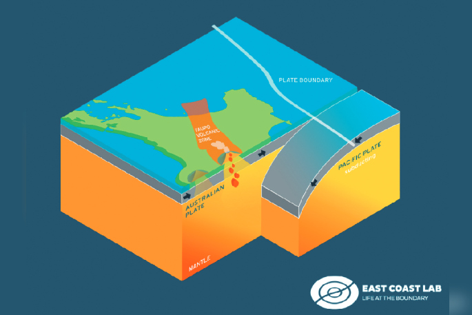 Plate shifts: The Hikurangi Subduction Zone is where the Pacific Plate dives beneath the Australian Plate on the east coast of the North Island. Image: East Coast Labs.
In October last year, it updated public tsunami evacuation information, delivering 7000 flyers to properties in coastal inundation zones.
Initial work has commenced on a multi-agency project focused on developing new evacuation processes and procedures for tsunami and flood risks. It is also developing Civil Defence Centres across the district to provide emergency resources to support the community after a natural hazard event.
The Earthquake Day event was born out of Dr Karetai’s work with GNS scientists over the past year on research project, Our Changing Coast, funded through the Ministry of Business, Innovation and Employment’s Endeavour Fund.
The project looks at factors such as vertical land movement and the impact of sea level rise on coastal communities.
As a doctor of psychology with a masters’ degree in environmental management, Dr Karetai was asked to investigate the impacts on youth living in coastal communities around the country.”
“The work has grown from there,” says Dr Karetai.
“We look at what concerns rangitahi now, where they are getting their information from and how they can know that it’s reliable information. That’s important because there’s so much misinformation around.
“A lot of their anxiety comes from not knowing where they can go for real information and how they know if they can trust it."
Earthquake Day is scheduled for June 25, with Our Changing Coast workshop for youth on June 26, and for adults on June 27. A talk by GNS principal scientist Richard Levy and earth scientist Tim Naish on June 26 will discuss sea level rise and their recent trip to Antarctica.
Based on how well the workshop went, they hoped to roll it out to all coastal New Zealand.
LDR is local body journalism co-funded by RNZ and NZ On Air.
![]()

0 comments
Leave a Comment
You must be logged in to make a comment.