
Continuing settled weather will cap off the working week, then MetService is forecasting rain to move swiftly northwards up the country for the last weekend of meteorological summer.
A couple of crisp mornings this week remind us that autumn is just around the corner.
Temperatures are on an increasing trend due to a northerly wind flow as the high pressure over the country starts shifting eastwards.
This high pressure keeps our weather dry, aside from brief showers here and there for parts of the North Island, until a front arrives on Friday night down south.
As this front moves northwards on Saturday, it will bring a burst of rain to the West Coast (heavier and more persistent in the ranges) while warm northwesterlies blow across the Southern Alps into Canterbury and Otago.
Heavy Rain Watches have been issued for much of the West Coast, as well as a Strong Wind Watch for the Canterbury High Country.
These warm dry winds in Canterbury on Saturday will pump temperatures into the high twenties.
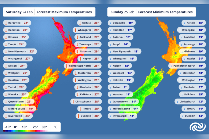 Metservice forecast map. Photo supplied.
“Make sure to follow the latest advice from Fire and Emergency NZ and check it’s alright before you light a fire at checkitsalright.nz,” says MetService meteorologist Dan Corrigan
“There will likely be a light sprinkling of rain in Canterbury on Saturday evening, but it won’t be enough to alleviate the dry conditions there.”
Saturday will also be a warm one for the North Island, then rain arrives overnight as conditions clear up further south.
While temperatures return to normal down south, North Islanders will be tossing aside their blankets with warm overnight temperatures not dipping below the high teens.
The wet weather then continues northwards on Sunday, bringing welcome rain to many areas that have had a very dry month so far.
“Monday is also likely to bring more rain to the upper North Island, but it is still some time away so the finer details of where, when, and how much are yet to be locked in,” says Dan.
“Keep an eye on metservice.com or our mobile app to stay up with the latest updates.”

0 comments
Leave a Comment
You must be logged in to make a comment.