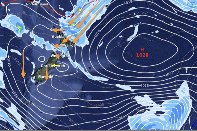
An airflow from Rarotonga which has been spreading across the top of New Zealand on Sunday with a weak low north of the country interacting with high pressure, is now centred east of the Chatham Islands.
WeatherWatch says this high pressure is still slowly sliding eastwards off the country and "this places a humid northerly quarter flow over many regions".
MetService has issued a severe weather warning for Gisborne/Tairawhiti and Westland.
"On Monday, a humid east to northeast flow is expected to affect Gisborne/Tairawhiti, bringing a period of heavy rain to the region where a Warning and Watch are in force," says a MetService spokesperson. "An active trough is forecast to move across the Westland and Grey Districts, bringing a period of heavy rain with localised thunderstorms and downpours possible. A Watch is now in force." The Heavy Rain Watch for Gisborne/Tairawhiti south of Tolaga Bay is valid for 13 hours from 3am to 4pm Monday January 22. A period of heavy rain, and amounts may approach warning criteria. The Heavy Rain Watch for the Westland and Grey Districts is valid for 13 hours from 11pm Sunday January 21 to 12pm Monday January 22. Periods of heavy rain and amounts may approach warning criteria. Thunderstorms and localised downpours of 25 to 35 mm per hour are possible.
Further heavy rain is likely on Monday night and early Tuesday morning.
"Winds may pick up in the north of NZ in eastern coastal areas, and other eastern parts of the country like Dunedin and Otago Peninsula," says a WeatherWatch spokesperson.
"The low to the north of New Zealand may drive in some rain or showers in that humid nor-east flow moving into East Cape, Bay of Plenty and coastal areas of the east over/up to Northland.
"Most of the rain will be offshore but some areas may get brushed by some heavier falls. Gisborne and Hawke’s Bay also might have a few showers."
Isolated downpours forming over the central/inland North Island with heat and humidity mean afternoon thunderstorms are also possible.
"Some showery weather remains in West Coast but it’s dry in the east with cooler days from Kaikoura to Dunedin. A few showers are possible in Southland too.
"For northern NZ the muggy weather comes with a chance of maximum temperatures in the low 30s and Humidex (feels like) temperatures in the late 30s or 40s.
Cooler airflows start to shift in across Monday over the South Island up to the lower North Island, then after Tuesday further north – easing the mugginess.
The new WeatherWatch app shows hourly humidity levels and temperatures in easy to view graph form (free to view) and the PRO (paid) version allows you to customise multiple alerts for temperatures across four locations to get push notifications on your device.

Use the QR code for details on the new WeatherWatch App – and links to download it.
If you’re camping in a tent or awning then download the new WeatherWatch App using the QR code above so you can see wind gust graphs at your location. Winds of 20km per hour or greater and gusts of 40km per hour or greater can be frustrating when in a tent or awning.

0 comments
Leave a Comment
You must be logged in to make a comment.