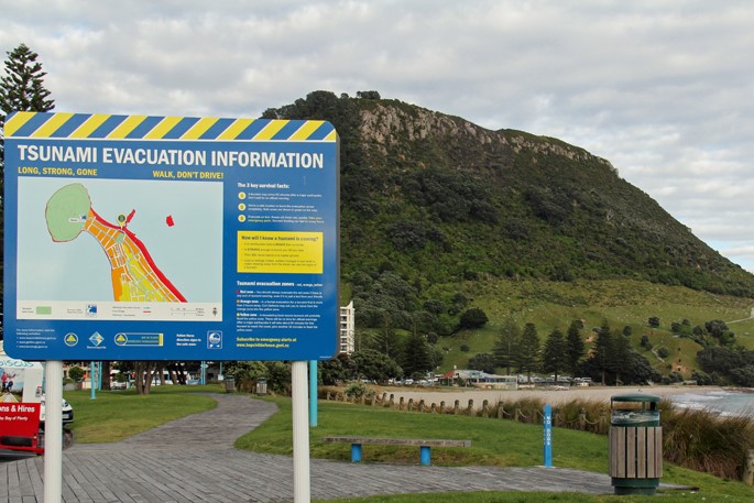
Living by the coast means that we should always be prepared for a tsunami.
“The best ways to be prepared for a tsunami are to know your local tsunami evacuation map and nearest tsunami safe location, and have an emergency grab bag prepared and ready to go should you need to evacuate,” says Tauranga Emergency Management team leader Dan Pearce.
Are you relying on sirens to warn you of a tsunami?
Pearce says Tauranga does not use sirens, like many other regions and districts throughout the country.
Likely, there will not be time to issue a warning for a local tsunami, he says.
This means that it is vital that people can recognise the natural warning signs.
“A long or strong earthquake is the natural warning for a tsunami,” says Pearce.
“If you feel an earthquake that is longer than a minute or strong enough that it’s hard to stand up, evacuate as soon as the shaking stops.”
Pearce says people should not wait for an official warning as there would not be enough time.
“A tsunami wave could reach our coastline within 40 minutes. If an earthquake occurs further away we may not feel it.
“If there is a tsunami threat to New Zealand, the national warning will be issued and Emergency Management Bay of Plenty can provide alerts and information on areas, if any, that need to be evacuated.
“This can be done through emergency mobile alerts, radio, TV broadcasts, social media, and local council websites.”
Tsunami-safe locations are identified on council’s tsunami evacuation maps.
“These can be found on signage at coastal areas, at Tauranga City Council service centres, and online at www.tauranga.govt.nz/tsunami.”
For those thinking about getting in the car and hitting the highway in this situation, think again.
“It’s not recommended to drive to tsunami-safe locations as this can very quickly cause traffic gridlock in an evacuation situation.
“It’s best to walk, cycle or run to tsunami-safe locations as modelling shows these can be reached within a safe timeframe before a maximum credible tsunami arrives.”
Pearce warns people to avoid heading towards the coast to watch the tsunami.
“Head to higher ground or your nearest safe location.
“Tauranga tsunami evacuation maps were updated in late 2023 to show a single, blue evacuation area and tsunami-safe locations.”
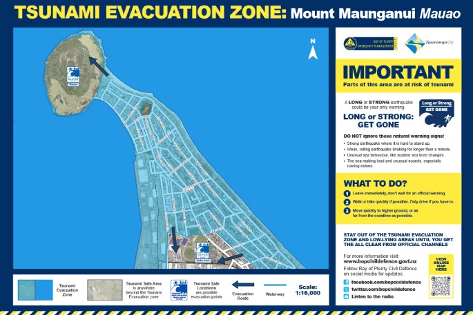 Tsunami evacuation zone: Mount Maunganui Mauao. Photo supplied www.tauranga.govt.nz/tsunami.
In the event of a tsunami, residents should head to the identified safe locations or out of the blue area shown on the map.
The blue area is the tsunami evacuation zone and is shown on the map of Mount Maunganui below.
“All tsunami-safe locations have been identified on several factors, including height above sea level, and nearby dune systems or waterways which can quickly reduce the impact of a tsunami as it moves inland.”
Sand dunes work as an excellent first line of defence against tsunamis.
“Water will lose a lot of power as it encounters the dunes, even as it overtops them or travels around them.
“Our tsunami evacuation maps are based on a maximum credible event, which is a magnitude 9 earthquake along the Kermadec Trench, which is a one-in-2500-year event,” says Pearce.
“A tsunami is one of the hazards that we plan for.”
Further information on how to prepare your household for an emergency is available at Tauranga City Council’s website as well as www.bopcivildefence.govt.nz.

0 comments
Leave a Comment
You must be logged in to make a comment.