A ridge of high pressure is expected to bring settled weather, before the next rain-maker arrives from the west.
This means there is a promise of sunshine for most at some time between Friday and Saturday before wet weather sets in during the second half of the weekend.
Today, the last vestiges of a departing front will bring the occasional shower over the North Island.
This paves the way for a high-pressure ridge to establish itself across the country by Friday.
“While a high-pressure ridge typically heralds stable conditions, localised showers are possible on Friday, particularly in inland areas of the North and South Islands. For the Bay of Plenty and central North Island, these may even evolve into isolated thunderstorms,” says MetService meteorologist Mmathapelo Makgabutlane.
Heading into the weekend, the ridge of high pressure moves onto the North Island, while a frontal weather system approaches the South Island from the southwest.
The front brings rain and showers with it as it moves up the South Island during the latter parts of Saturday and over the North Island during Sunday.
"For those planning end-of-year functions and local Christmas parades, the initial part of the weekend offers the most favourable conditions before the front makes its presence felt later on Saturday."
Heavy Rain Watches are in effect for Fiordland, the West Coast Region, and the headwaters of Otago and Canterbury lakes and rivers.
"This weather system is poised to deliver a substantial amount of rain. Keep an eye out for potential upgrades to these Watches in the days ahead."
Sunday is earmarked for wet conditions in the lower and eastern North Island, as the front traverses the region.
However, as it advances northward, its intensity wanes, confining the remaining North Island to sporadic showers to conclude the weekend.
Brisk northwesterly winds, associated with the front, will be felt across the South Island and lower North Island, triggering a Strong Wind Watch for the lower and central South Island from Saturday afternoon to Sunday morning, with a possibility of severe gale winds.
This risk extends to Marlborough, Wellington, and the Wairarapa on Sunday.
The northwesterly wind flow brings warmth to Otago and Canterbury coasts, along with Marlborough on Saturday, with temperatures reaching 26°C and 27°C in Christchurch and Blenheim respectively, and a balmy 24°C in Dunedin City.
Further afield, Severe Tropical Cyclone Jasper is now at Category 3, charting a southwestward course and is anticipated to reach Australia’s East Coast early next week.
The Australian Bureau of Meteorology continues to monitor its trajectory, and as of now, no impact on Aotearoa New Zealand is expected.
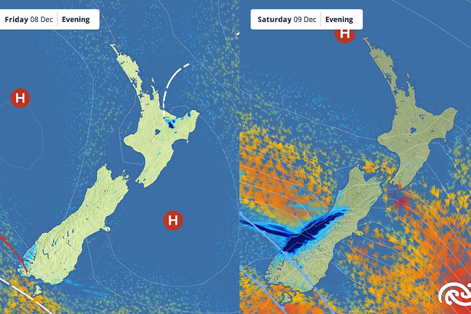 Image: MetService.

0 comments
Leave a Comment
You must be logged in to make a comment.