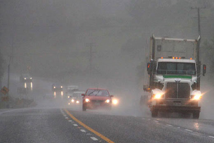
A severe weather watch for heavy rain for the Bay of Plenty is now being upgraded to a warning.
The remnants of TC Lola is lashing the upper North Island, with several thousand homes without power in Northland this morning. Read more here.
In it's latest weather update, the MetService says heavy rain and severe gales are barrelling down the county today.
"A large, deep, complex low pressure system just north of New Zealand is moving slowly southsoutheast.
"Fronts and troughs associated with this low are expected to bring heavy rain and severe gales to some northern and eastern North Island areas.
"Warnings and Watches are in force. Please keep up to date with forecasts."
Roads closed in Coromandel after surface flooding
Kauaeranga Valley Rd in the Coromandel has been closed due to flooding, Thames-Coromandel District Council reports.
The Waikato Regional Council monitoring station shows the river rising from 6m to 10m on Monday morning.
Victoria Street, in Thames, has also been closed due to surface flooding at the second ford 900m from the start of the road
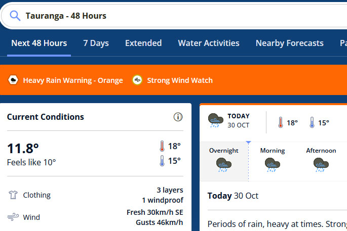 Image: MetService.
Heavy Rain Warning - Orange
Heavy rain may cause streams and rivers to rise rapidly. Surface flooding and slips are also possible and driving conditions may be hazardous.
Area: Coromandel Peninsula
Valid: 24 hours from 9am Mon 30 Oct to 9am Tue 31 Oct
Forecast: Expect 100 to 120 mm of rain in addition to rain which has already accumulated. Peak rates of 15 to 25 mm/h Monday, with thunderstorms possible.
Area: Bay of Plenty west of Matata including Rotorua
Valid: 24 hours from 9am Mon 30 Oct to 9am Tue 31 Oct
Forecast: Expect 90 to 120 mm of rain. Peak rates of 10 to 25 mm/h at times.
Area: Tairawhiti/Gisborne from Tolaga Bay northwards
Valid: 31 hours from 9am Mon 30 Oct to 4pm Tue 31 Oct
Forecast: Expect 130 to 160 mm of rain. This rain comes in addition to rain which has already accumulated. Peak rates of 15 to 25 mm/h, especially Tuesday afternoon in possible thunderstorms.
Area: Tairawhiti/Gisborne south of Tolaga Bay
Valid: 28 hours from 1pm Mon 30 Oct to 5pm Tue 31 Oct
Forecast: Periods of heavy rain, especially about the ranges. Expect 100 to 140 mm of rain. Peak rates of 15 to 25 mm/h expected at times, especially Tuesday afternoon in possible thunderstorms.
Area: Inland ranges of Hawke's Bay south of State Highway 5
Valid: 27 hours from 2pm Mon 30 Oct to 5pm Tue 31 Oct
Forecast: Expect 110 to 140 mm of rain. Peak rates of 10 to 20 mm/h, but 15 to 25 mm/h Tuesday afternoon in possible thunderstorms.
Strong Wind Warning - Orange
Strong wind gusts could damage trees, powerlines and unsecured structures. Driving may be hazardous, especially for high-sided vehicles and motorcycles.
Area: Coromandel Peninsula
Valid: 2 hours from 9am Mon 30 Oct to 11am Mon 30 Oct
Forecast: Severe gale east to southeast winds gusting 120 km/h in exposed places.
Heavy Rain Watch
Area: Northland
Valid: 23 hours from 9am Mon 30 Oct to 8am Tue 31 Oct
Forecast: Periods of heavy rain, and amounts may approach warning criteria.
Strong Wind Watch
Area: The Kaimai Range and eastern Waikato
Valid: 2 hours from 9am Mon 30 Oct to 11am Mon 30 Oct
Forecast: East to southeast winds may approach severe gale in exposed places.

0 comments
Leave a Comment
You must be logged in to make a comment.