.jpg)
Warning: Video contains offensive language.
9.15am update: Police are advising members of the public to avoid Seaforth Road in Waihi Beach while emergency services respond to a weather-related incident in the area.
Earlier, rooftops were torn off, powerlines have been brought down and parts of the road are blocked.
"A further release will be issued when the area is safe to access," says a police spokesperson.
Earlier, 9am: Rooftops have been ripped off houses at Waihi Beach on Saturday morning following a tornado through the township.
Waihi Beach resident Shelz Lynette says powerlines are down across the road on the left hand side of Seaforth Ave heading towards Bowentown.
"And it's blocked up near Cirtis Ave," says Shelz.
"Roof tops are off down Waihi Beach."
Powerco is reporting that 990 Waihi Beach properties have had a power outage. A site investigation is underway.
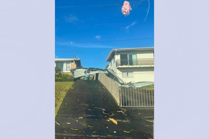
Roofs torn off at Waihi Beach. Photo: Shelz Lynette.
MetService had issued a severe thunderstorm watch for the area for the period from 7am - 11am on Saturday. At 7.15 am, the MetService weather radar detected severe thunderstorms near Waihi and Waihi Beach, and expected that the thunderstorms would lie near Waihi Beach and Katikati at 7.45am and near Katikati at 08:15 am.
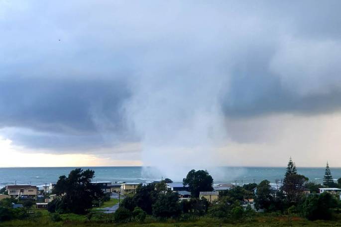
The tornado was filmed by Shelz Lynette from her home at Athenree and Penny Andrews at Waihi Beach from about 8am on Saturday morning.
"It was first travelling from Tuhua to Waihi Beach," says Shelz Lynette. "Currently forming [along the] shoreline at Bowentown.
"My son woke me up to see it. The one currently forming travelling over Bowentown towards Matakana Island is growing by the second."
Shelz fllmed the tornado from the top end of Koutunui, directly looking out towards Tuhua., and says it was moving towards the direction of Matakana Island and Mount Maunganui.
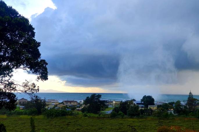
Tornado at Waihi Beach on Saturday morning, February 25. Photo: Shelz Lynette.
Kasey Andrews says it was the "scariest thing ever", while her mother Penny Andrews filmed it from her home at Waihi Beach
At first Penny's video is showing dark clouds with some swirling motion, as she notices the unusual disturbance.
"It's like a little tornado,' says Penny, as she starts fillming from the second floor of her home looking out over the balcony. Seconds later, she bursts out with "it IS a frickin tornado! It's a bloody tornado! It's just taken a house or something!"
On the video sheets of iron can be seen swirling up into the air above the houses and the tornado could be seen forming a long spiral from the dark clouds above down to the ground.
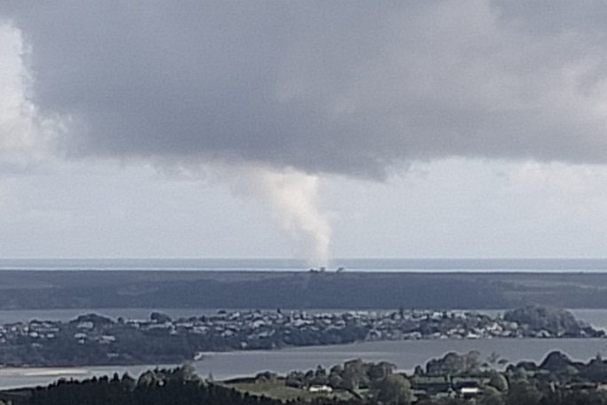
The view towards Matakana Island from the top of Minden Road. This photo was taken at about 10.05am on Saturday. Photo: Alison Pickering.
A powercut at Waihi Beach is affecting 990 properties, says PowerCo.
"There's about 13 cars and a lot of people enjoying Miss Jay's Coffee Cart due to the power being out," says Shelz.
"She has about 18 cutomers at the moment in line and is powering on like a trooper!"
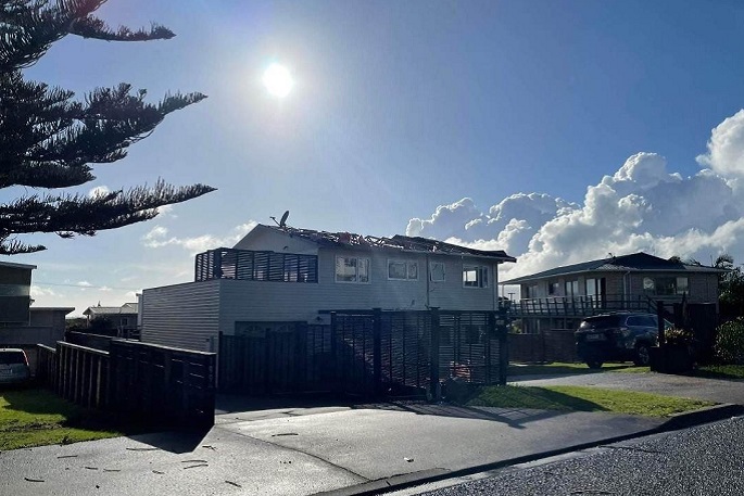
Roofing iron was lifted off houses at Waihi Beach by the tornado. Photo: Connor Hendrie.
MetService has issued a severe thunderstorm watch for Bay of Plenty and Hawke's Bay
A few very heavy showers and/or thunderstorms are expected to affect parts of Bay of Plenty this morning, especially western Bay of Plenty.
Between 8am and midday today, these very heavy showers or isolated thunderstorms may affect the area between Waihi Beach and Opotiki, with localised downpours of 20-40mm per hour.
Rainfall of this intensity can cause surface and/or flash flooding, especially about low-lying areas such as streams, rivers or narrow valleys, and may also lead to slips.
Driving conditions will also be hazardous with surface flooding and poor visibility in heavy rain.
This downpour risk should ease by midday. Hawkes Bay and Tararua A rain-band over Hawkes Bay and the Tararua District will move slowly southwards today.
Within and behind the rain-band there is a moderate risk of thunderstorms, starting in Central and Southern Hawkes Bay from late morning, and the Tararua District this afternoon.
These thunderstorms, if they occur, should produce rainfall mainly in the 10-25mm per hour range, however there is also a low risk of localised downpours of 25-40mm per hour.
If rainfall of this higher intensity does occur, it can cause surface and/or flash flooding, especially about low-lying areas such as streams, rivers or narrow valleys, and may also lead to slips.
Driving conditions will also be hazardous with surface flooding and poor visibility in heavy rain.
The thunderstorm risk eases this evening. This Severe Thunderstorm Watch for Hawke's Bay is valid from 11am - 8pm on Satuday February 25 A Severe Thunderstorm Watch means conditions are favourable for severe thunderstorms in and close to the watch area. People in these areas should be on the lookout for threatening weather conditions and monitor for possible Severe Thunderstorm Warnings.
Tornado at Waihi Beach on Saturday morning, February 25. Photo: Shelz Lynette.

0 comments
Leave a Comment
You must be logged in to make a comment.