


The remnants of a tropical depression may feed into a new area of low pressure near New Zealand next week bringing a new period of wind and rain to the North Island, says WeatherWatch.
"It's a messy set up with a lot of disorganised low pressure,' says a WeatherWatch spokesperson.
"Disorganised' meaning lows that don't look circular and seem messy in their design, not spinning properly, tricky to forecast movement etc. However next week this area of low pressure may merge into a storm near NZ."
WeatherWatch say 'storm' criteria means "gales all the way around the centre".
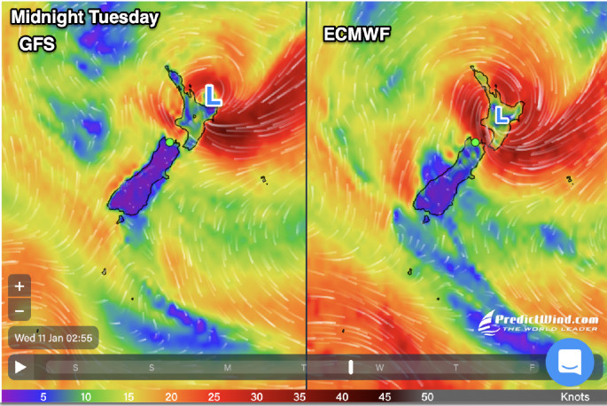
Map powered by PredictWind.com
"Either way – put simply – there is another period of unsettled weather for the North Island this coming week, mostly around Tuesday and Wednesday, due to a deepening low developing on NZ's front door step."
WeatherWatch say that precise tracking is not yet locked in, but they have the latest maps available for people to see current thinking.
"Today the JTWC (US Joint Typhoon Warning Center) announced a tropical storm had formed far away in the Coral Sea," says a WeatherWatch spokesperson.
"However it's up to Australia's BoM or Fiji MetService to officially name it – neither have done so at the time we published and didn't indicate they weren't going to today. The low may not really kick into an official tropical cyclone – but may well end up still pulling tropical energy down towards the NZ area to add more fuel to our weather. It's unrelated to our weather today – but may not be by mid next week."
The US Joint Typhoon Warning Center has announced a tropical storm has formed in the Coral Sea... however, no official word from BoM.
— WeatherWatch.co.nz (@WeatherWatchNZ) January 6, 2023
For now, it's an offshore disturbance that may not cause serious issues - but worth monitoring.
Map 1: JTWC
Map 2: BoM pic.twitter.com/qDp7oy8xdH
WeatherWatch say various reliable computer modelling continues to get more aligned, showing a period of rain and wind for the North Island early to mid next week.
"Some trustworthy modelling shows the deep low pulling to NZ's east, whilst two other reliable models show it directly affecting the North Island due to blocking high pressure to our east,' says a WeatherWatch spokesperson.
"Unlike the severe weather event the North Island has just had, this one should move through a little faster – within 48 hours and likely clearing NZ by Thursday. However if it directly hits the island then we can expect pockets of severe weather across the island, not just in one zone to the north."
WeatherWatch are taking care to point out that they are not currently forecasting a tropical cyclone to hit New Zealand, "but our weather next week may well be connected to tropical low pressure".
"There is still a chance this system could slide just east of us and not cause too many headaches for NZ but there's enough data to suggest those in the North Island should be aware of what is potentially developing."
Windiest weather looks to be at various places around the North Island on Tuesday and Wednesday.
"Unlike the squash zone wind event we just had that brought gusty winds from one direction to mostly one part of the island for days, this system can bring various wind directions to many different regions within 48 hours."
Eastern areas, like Gisborne, Hawke's Bay, BoP and Coromandel Peninsula may be most impacted. To follow wind maps click here
Rain
WeatherWatch say much of the North Island will be getting rain this week
"Our rain accumulation maps currently show Coromandel Peninsula, parts of BoP but especially East Cape, Gisborne and Hawke's Bay most exposed to rain from this event next week."
Good news
After this low next week WeatherWatch.co.nz is forecasting high pressure to return and a more settled, sunny, summer-like spell of weather for the country.
"Summer is not done yet! We expect more high pressure to cross NZ for the rest of January (with a few afternoon downpours in the mix). The tropics is very active though – and those who like watching for cyclones should be monitoring conditions between Australia and Fiji, in particular over the next couple of weeks."

0 comments
Leave a Comment
You must be logged in to make a comment.