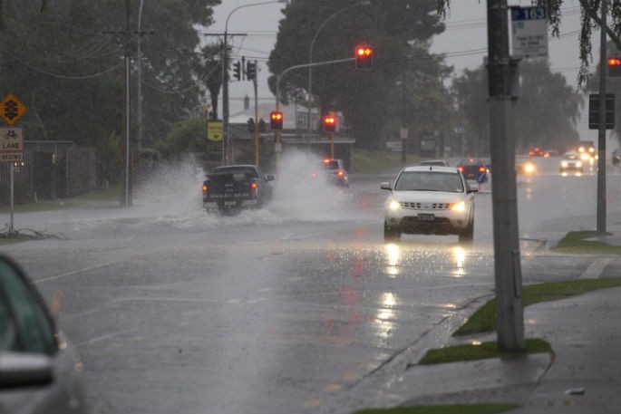
With the wild weather touching down, MetService is issuing an update to their heavy rain warning for Bay of Plenty and the Coromandel Peninsula.
The Coromandel rain warning is in place from 9.00am Thu 5 January to 12.00pm Fri 6 January.
For the Bay of Plenty, the warning is in place for west of Whakatane and north of Rotorua from 9.00am Thu 5 January to 12.00am Sat 7 January.
"Heavy rain could cause slips, surface flooding and damage to roads. Severe gales could make driving conditions hazardous, especially for motorcycles and high sided vehicles. Trees may be toppled and power lines damaged. Temporary structures such as tents could be affected," says a MetService spokesperson.
"A subtropical low over the Tasman Sea directs a strong and moist northeast flow over New Zealand, with some areas likely to receive warning amounts of rain and possible severe gale northeasterlies. Also note that large northeast swells could bring hazardous conditions to exposed coasts."
"People are advised to keep up to date with the latest forecasts from MetService in case any changes are made, or further areas are added."
Here are the full list of rain warnings across the country:
Heavy rain may cause streams and rivers to rise rapidly. Surface flooding and slips are also possible and driving conditions may be hazardous.
Area: Coromandel Peninsula Valid: 27 hours from 9:00am Thu 5 January to 12:00pm Fri 6 January Forecast: Expect a further 140 to 200 mm on top what has already fallen, with lesser amounts nearer the coast. Peak rates of 10 to 20 mm/h. Note that this warning may be extended since further bursts of heavy rain are possible during the remainder of Friday.
Area: Bay of Plenty west of Whakatane and north of Rotorua Valid: 39 hours from 9:00am Thu 5 January to 12:00am Sat 7 January Forecast: West of Matata: Expect further 180 to 240 mm of rain on top of what has already fallen, with lesser amounts nearer the coast. Peak rates of 15 to 25 mm/h expected. Between Matata and Whakatane: Expect further 120 to 150 mm of rain on top of what has already fallen, with lesser amounts nearer the coast. Peak rates of 10 to 20 mm/h expected. Note that this warning period may be extended since further bursts of heavy rain are possible during Saturday.
Area: The Richmond and Bryant ranges including the Rai Valley, also the Marlborough Sounds Valid: 27 hours from 9:00am Thu 5 Jan to 12:00pm Fri 6 Jan Forecast: Expect 120 to 150 mm of rain, mainly about the western ranges. Peak rates of 10 to 20mm/h expected.
Area: Tasman west of Motueka Valid: 27 hours from 9:00am Thu 5 January to 12:00pm Fri 6 January Forecast: Expect further 150 to 220 mm of rain, mainly about the ranges. Peak rates of 15 to 25 mm/h expected from Thursday evening until Friday morning.
Area: The ranges of Westland south of Otira Valid: 27 hours from 9:00am Thu 5 January to 12:00pm Fri 6 January Forecast: Expect further 120 to 150 mm of rain on top of what has already fallen. Peak rates of 10 to 20 mm/h expected.
Here are the severe weather watches across the country:
Heavy Rain Watch
Area: Auckland including Great Barrier Island Valid: 24 hours from 9.00am Thu 5 Jan to 9.00am Fri 6 Jan Forecast: Periods of heavy rain. Rainfall amounts may approach warning criteria, mainly in the east. Area: Northern Taranaki west of Matau Valid: 33 hours from 9.00am Thu 5 Jan to 6.00pm Fri 6 Jan Forecast: Periods of heavy rain. Rainfall amounts may reach warning criteria, mainly about Mount Taranaki. Strong Wind Watch
Area: Auckland including Great Barrier Island Valid: 9 hours from 9.00am Thu 5 Jan to 6.00pm Thu 5 Jan Forecast: Northeasterly winds may approach severe gale at times. Area: Waikato, Coromandel and western Bay of Plenty to Taranaki and Taihape Valid: 6 hours from 9.00am Thu 5 Jan to 3.00pm Thu 5 Jan Forecast: Northeast winds may approach severe gale in exposed places.

0 comments
Leave a Comment
You must be logged in to make a comment.