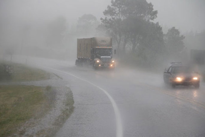
MetService has issued a severe weather warning as heavy rain and gales is expected for many parts of New Zealand
A front is forecast to move slowly southwards over northern and central New Zealand today and Tuesday.
"This front is preceded by a broad band of rain, with some heavy falls, and east to northeast gales," says a MetService spokesperson.
"An associated low to the west of the upper North Island should also move slowly southwards today and Tuesday, then weaken and cross the South Island during Wednesday."
Warnings and Watches for heavy rain and severe gales are in force for many parts of the country.
People are advised to keep up to date with the latest forecasts in case any changes are made, or further areas are added.
A heavy rain warning has been issued for the following regions:
Heavy rain may cause streams and rivers to rise rapidly. Surface flooding and slips are also possible and driving conditions may be hazardous.
Northland
Valid: 12 hours from 10:00 am to 10:00 pm Monday
Forecast: Expect a further 60 to 90 mm of rain to accumulate on top of what has already fallen about northeastern areas north of Whangarei, and 40 to 70 mm of rain elsewhere. Peak intensities of 10 to 15 mm per hour, but 20 mm per hour possible in localised areas
this afternoon.
Auckland from Whangaparaoa northwards, also Great Barrier Island
Valid: 16 hours from 10:00 am Monday to 2:00 am Tuesday
Forecast: Expect a further 60 to 80 mm of rain to accumulate on top of what has already fallen. Peak intensities of 10 to 20 mm per hour from this afternoon.
Coromandel Peninsula
Valid: 20 hours from 10:00 am Monday to 6:00 am Tuesday
Forecast: Periods of heavy rain. Expect a further 110 to 160 mm of rain to accumulate on top of what has already fallen about high ground, and 80 to 110 mm elsewhere. Peak intensities of 10 to 20 mm per hour.
Bay of Plenty from Kawerau westwards
Valid: 20 hours from 1:00 pm Monday to 9:00 am Tuesday
Forecast: Expect 120 to 160 mm of rain to accumulate, especially inland. Peak intensities of 10 to 20 mm per hour.
Mount Taranaki
Valid: 20 hours from 10:00 am Monday to 6:00 am Tuesday
Forecast: Periods of heavy rain. Expect 100 to 150 mm of rain to accumulate.Peak rates of 10 to 15 mm per hour.
Change note: Upgraded to an orange warning.
Tasman about and west of Motueka
Valid: 18 hours from 3:00 pm Monday to 9:00 am Tuesday
Forecast: Expect 80 to 120 mm of northeasterly rain to accumulate, especially about the ranges. Peak intensities of 10 to 20 mm per hour.
Note, further rain or showers through to Tuesday night.
Canterbury south of Rakaia River
Valid: 26 hours from 1:00 am Tuesday to 3:00 am Wednesday
Forecast: Periods of heavy rain. Expect 100 to 130 mm of rain to accumulate about the foothills, and lesser amounts elsewhere. Peak rates of 10 to 15 mm per hour.
North Otago
Valid: 26 hours from 6:00 am Tuesday to 8:00 am Wednesday
Forecast: Expect 100 to 130 mm of rain to accumulate, especially inland. Peak rates of 10 to 15 mm per hour.
Dunedin
Valid: 26 hours from 7:00 am Tuesday to 9:00 am Wednesday
Forecast: Periods of heavy rain. Expect 60 to 90 mm of rain to accumulate. Peak rates of 10 to 15 mm per hour.
A heavy rain watch has also been issued for these areas:
Auckland south of Whangaparaoa
Valid: 18 hours from 10:00 am Monday to 4:00 am Tuesday
Forecast: Periods of heavy rain, and rainfall accumulations may approach warning criteria.
Bay of Plenty east of Kawerau, and Gisborne from Ruatoria northwards
Valid: 15 hours from 9:00 pm Monday to 12:00 pm Tuesday
Forecast: Periods of heavy rain, and accumulations may approach warning criteria.
Marlborough
Valid: 16 hours from 8:00 pm Monday to 12:00 pm Tuesday
Forecast: A period of heavy easterly rain. Rainfall accumulations may
exceed warning criteria, especially about the Kaikoura Ranges.
Canterbury from Rakaia River northwards
Valid: 18 hours from 12:00 am to 6:00 pm Tuesday
Forecast: Periods of heavy rain. Rainfall amounts may approach warning criteria.
A strong wind warning has been issued for the following regions:
Strong wind gusts could damage trees, powerlines and unsecured structures. Driving may be hazardous, especially for high-sided vehicles and motorcycles.
Northland
Valid: 9 hours from 10:00 am to 7:00 pm Monday
Forecast: Severe northeast gales gusting 120 km/h in exposed places.
Auckland including Great Barrier Island
Valid: 16 hours from 10:00 am Monday to 2:00 am Tuesday
Forecast: Severe northeast gales gusting 110 km/h in exposed places.
A strong wind watch has been issued for these areas:
Coromandel Peninsula and Bay of Plenty
Valid: 12 hours from 6:00 pm Monday to 6:00 am Tuesday
Forecast: Northeast winds may approach severe gale in exposed places.
Eastern Waikato
Valid: 17 hours from 10:00 am Monday to 3:00 am Tuesday
Forecast: Northeast winds may approach severe gale in exposed places, especially near the Kaimai Range.
Buller
Valid: 15 hours from 3:00 pm Monday to 6:00 am Tuesday
Forecast: Easterly winds may approach severe gale in exposed places.

1 comment
Frustrating.
Posted on 25-07-2022 13:02 | By The Professor
The weather is frustrating at the moment, but not as frustrating as seeing it all soak away. Infrastructure in our region, for the collection and storage of water is poor at best. It'll soon be the case where the Councils will tell us to reduce water usage and to stop using sprinklers and hose pipes because there is insufficient water to go around an ever rapidly growing population.
Leave a Comment
You must be logged in to make a comment.