
UPDATE 8.35AM: As forecast yesterday an active cold front is this morning moving into the western side of NZ with scattered thunderstorms, squalls and even hail, reports WeatherWatch.co.nz
"Large hail has been recorded on the West Coast with a damaging shower a short time again producing hail larger than grapes," says a spokesperson for the weather organisation.
"Severe thunderstorms are impacting the lower North Island with more isolated storms elsewhere.
"The weather in the coming days will be similar with several surges of squally showers off the Tasman Sea caused by a storm still deepening south of NZ - and likely to remain there until early next week."
 EARLIER:

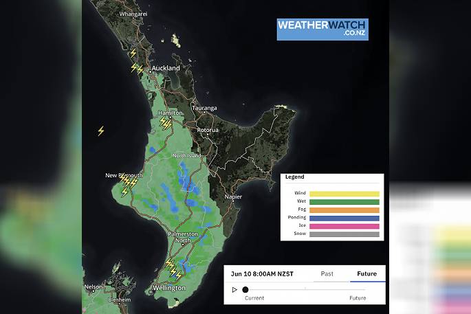
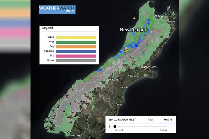
With a cold front pushing over the North Island today then another one over the South Island this evening and overnight, people are warned to expect strong westerly quarter winds today with heavy falls in the west particularly when fronts move through.
A number of fronts will move through from the Tasman Sea over the coming days as a storm in the Southern Ocean continues to grow and deepen.
WeatherWatch.co.nz says the off and on stormy weather will linger in NZ until the middle of next week, all generated by the same system.
#6AMThe next cold front is moving into the North Island with squalls, #thunderstorms and heavy downpours. Fast moving, followed by more showers & wind.
— WeatherWatch.co.nz (@WeatherWatchNZ) June 9, 2022
Track Live #Radar here: https://t.co/sZ6VGdTVQY
(@MetService just issued a severe T-Storm Warning for #Wellington radar) pic.twitter.com/DOqZccagk3
Northland, Auckland, Waikato & Bay Of Plenty A few showers and sunny spells, Bay Of Plenty may have a dry morning. Downpours develop this morning or early afternoon spreading in from the west thanks to a front, rain may be heavy with thunderstorms then easing. Breezy northwesterlies, perhaps strong for a time in the west. Highs: 15-17
Western North Island (including Central North Island) Rain develops in the morning, a few heavy falls and perhaps thunderstorms then easing to showers in the afternoon. Strong northwesterlies. Highs: 10-16
Eastern North Island Morning rain about Wairarapa, there may be a few spits further north around midday as a front passes over otherwise perhaps just some cloud moving through. Mostly sunny otherwise with blustery northwesterlies, strong winds for Wairarapa. Highs: 14-19
Wellington Morning downpours eases, perhaps some sun may break through. Overnight rain moves back in. Strong to gale northwesterlies, strongest winds will be first thing in the morning then again at night. High: 14-15
Marlborough & Nelson Morning rain, clearing to sun by midday, more so for eastern Marlborough. Nelson and the Sounds could continue to see a few showers. Northwesterlies, strong to gale about the Sounds and in Golden Bay. Rain moves back in later in the evening with winds becoming stronger in the above mentioned areas. Highs: 12-14
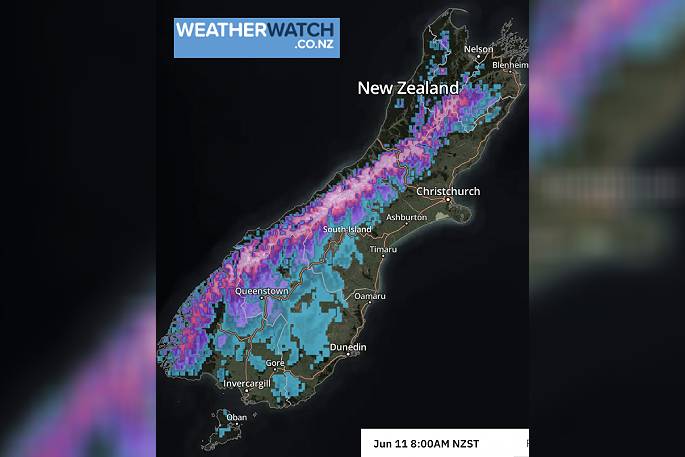
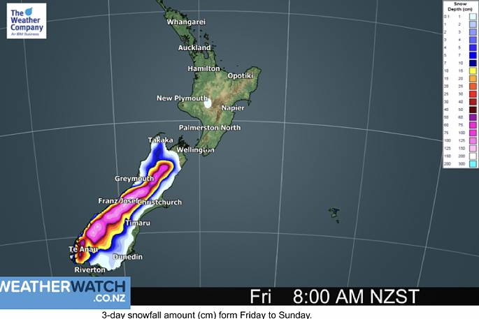
Canterbury Early rain, heavy in the high country then clearing and becoming mostly sunny, northerlies strengthen in the evening with gales possible, heavy rain moving back into the high country and a few falls spreading eastwards, clearing again overnight. Snow to 800m in the high country closer to the Main Divide. Highs: 10-16
West Coast Heavy rain first thing then easing to showers, rain develops again in the evening with heavy falls, possible thunderstorms and hail too. Strengthening northerlies from afternoon, gales develop then changing strong to gale westerly later on. Snow to 500m about the ranges of Fiordland at night, 800m further north. Highs: 7-14
Southland & Otago Early spots of rain clear then sun breaks through, rain develops again in the evening (heavy about the Lakes District), easing to showers overnight as northerlies change westerly. Snow overnight to 500m for Southland and the western ranges (closer to Fiordland). Highs: 9-10

0 comments
Leave a Comment
You must be logged in to make a comment.