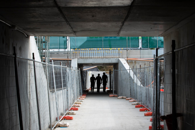
While the new Bayfair underpass is open for use, people are being advised that it is not yet finished.
The new Bayfair underpass which has been available for use from April 20 for people crossing State Highway 2/Maunganui Road.
It's has been opened to fascilitate convenient access for pedestrians, cyclists and other users, says the Waka Kotahi Transport Agnecy.
Prior to the end of the Bay Link project, the underpass will close for final completion work, although by then people walking and cycling will be able to cross via the new signalised crossing through the Bayfair roundabout.
'It's tremendous to have the underpass open for use, knowing how much it means to the community,” says Waka Kotahi NZ Transport Agency Regional Manager of Infrastructure Delivery, Jo Wilton.
'Providing safe shared use for all the community has been a key consideration for the new underpass.”
The underpass is a shared space and intended to be used by people on foot, bikes, scooters, mobility scooters and wheelchairs.
'We ask people to be considerate and take care.”
.jpg) The Bayfair roundabout before the overpass started to be put in place. Photo: NZTA.
The Bayfair roundabout before the overpass started to be put in place. Photo: NZTA.
NZTA are anticipating there will be around 1000 crossings per day through the underpass, which is fully lit at night.
'While the underpass remains a work in progress, temporary lighting has been installed that switches on automatically when the streetlights come on,” says Jo.
'At completion, there will also be decorative lighting above the entrances to the box sections of the underpass.”
A number of CCTV cameras will also be installed at completion.
.jpg) Further development of the Bayfair roundabout. Photo: NZTA.
Further development of the Bayfair roundabout. Photo: NZTA.
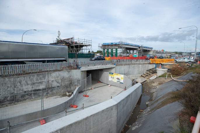
NZTA says the total cost of the Baypark to Bayfair project, announced in January 2021, is $262 million.
'The change of the project scope at an advanced stage of the construction programme to include the addition of the pedestrian and cycling underpass, along with complex ground conditions and the impact of Covid-19 at a critical time, has all had a cumulative impact on project cost,” says Jo.
An underpass was not included in the original project scope as Waka Kotahi followed best-practice recommendations based on international trends at the time.
'During the design process, grade-separated access for pedestrians and cyclists was not considered as high a priority as it is today.”
The community was consulted on the options between 2014 and 2017.
In August 2019, on hearing that the underpass which ran under State Highway 2 was set to be demolished with no plans for it to be replaced, hundreds of people turned out to a protest organised by the Bayfair Underpass Alliance.
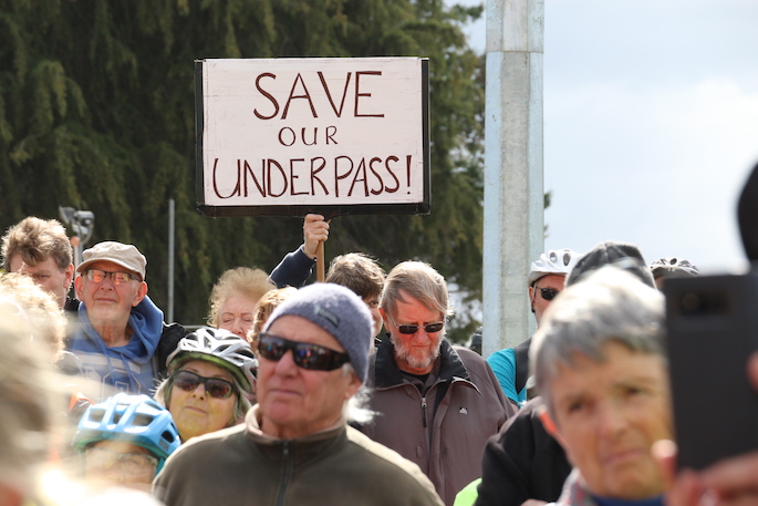 Hundreds protested at the Bayfair Underpass in August 2019. Photo: Daniel Hines/SunLive.
Amongst the hundreds of protesters was Tauranga Mayor Greg Brownless, who arrived on his bicycle. Greg was part of the council that put the underpass into place in the late 90s. The underpass was opened on July 10 1999 by then deputy mayor Stuart Crosby.
Greg's adamant that the decision made to demolish the underpass had not involved Tauranga City Council, but had been a decision made between NZTA and the contractors working on the Baylink Project.
Greg wrote to Mark Ratcliffe, the Interim Chief Executive at NZTA on August 15 and August 19 2019 urging the association to reconsider demolishing the underpass. Copies of the letters were also sent to Minister of Transport Phil Twyford.
In October 2019 the Bay Link Working Group was established to provide key community representatives and stakeholders the opportunity to consider the options for a grade-separated pedestrian and cycling facility. From that process it was clear an underpass was the community's preference.
'Waka Kotahi recognised the community's strong appetite for an underpass and changed the construction scope to achieve this,” says Jo.
The underpass is recognised as a key link in Tauranga's cycling network and will be regularly used by residents and school children walking and cycling between Matapihi, Bayfair and Arataki.
In combination with the ability to cross at ground level via the signalised pedestrian crossings through the new Bayfair roundabout, the underpass will provide a safer connection for people walking, cycling, using scooters and mobility scooters.
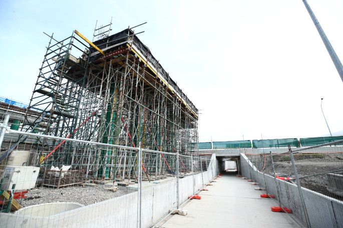
'The biggest challenge in creating the underpass has been the staging required to construct the underpass in the middle of State Highway 2 at the same time as maintaining two lanes of traffic in each direction. There have been numerous traffic switches in the area while the underpass has been built to accommodate various work zones alongside live traffic lanes.”
 The entrance to the Bayfair underpass. Photo: John Borren.
Jo says construction will be ongoing, and users can expect to see work happening in and around the area.
While the main structural elements of the underpass are in place, further works are required to complete it.
These include construction of the stairs at either end; finishing the ramp on the Matapihi side; planting and landscaping; filling the open trench sections on both sides and creating a slope with large rocks concreted in to form a decorative finish; and finishing the concrete work and painting
Prior to the end of the Bay Link project, the underpass will close for final completion work. At that time, people walking and cycling will be able to cross via the new signalised crossing through the Bayfair roundabout.
'We are working closely with local hapū Ngā Potiki, Ngāi Tukairangi and Ngāti Tapu on cultural design elements which will be incorporated into the underpass and across the wider Bay Link project,” says Jo.
How to access the underpass:
- People on foot, bikes, scooters, mobility scooters and wheelchairs approaching SH2 from Matapihi will be able to access the underpass via a new concrete ramp, which will meet the existing temporary footpath in front of Golf 360.
- The Bayfair exit/entrance to the underpass will also be via a new concrete ramp that connects with the Bayfair Shopping Centre carpark. A marked route will connect people with the outside of the shopping centre.
- Pedestrians and cyclists travelling to/from Girven Road should continue east around the outside of the shopping centre and onto the Girven Road footpath.
- Pedestrians and cyclists travelling to/from Mount Maunganui should follow the marked route around the centre's perimeter to the rear of Countdown before using the existing zebra crossing to connect with the footpath leading to SH2/Maunganui Road. Circular blue stickers placed at intervals on the ground will mark the route in both directions.
Construction activity will remain ongoing in the area so underpass users should take care.

1 comment
forward thinking...
Posted on 04-05-2022 19:14 | By hexsayer
sooo, now.. how are you going to keep it safe 24/7 for public access? i can see alot of potential negatives like graffiti/tagging, benevolent use by homeless and worstcase predatory behavior. what are councils mitigations?
Leave a Comment
You must be logged in to make a comment.