Forecasters say an ex-tropical cyclone in the Pacific is on a path that will likely blast it over the North Island, bringing severe gales for almost all the island, and heavy rain to its already flood-ravaged regions.
MetService meteorologist David Miller says the likelihood of ex-tropical cyclone Fili hitting NZ from Tuesday to Thursday, is growing.
Severe gales, heavy rain, large waves and coastal inundation for much of the North Island/Te Ika-a-Māui is on the cards.
Fili is tracking south-east from New Caledonia, and the latest MetService tracking path shows Northland, Auckland, Bay of Plenty, and the East Coast, which was ravaged by floods two weeks ago, are directly in its sights.
A heavy rain watch and a strong wind watch was issued on Sunday by MetService for eastern parts of Northland for 24 hours from noon on Tuesday.
Southeast winds are expected to turn southwest on Tuesday night or Wednesday morning, and winds from both directions may approach severe gale for a time, says the MetService.
A period of heavy rain is possible, and amounts may approach warning criteria, it says.
'Additional severe weather watches or warnings will probably be issued tomorrow for a number of regions that may be impacted by this weather system.”
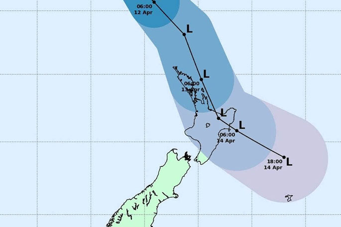 Ex-tropical cyclone Fili is tracking towards the north and east of the North Island, MetService says. Image: MetService.
In its severe weather outlook on Sunday afternoon, the forecaster said it has moderate confidence of severe weather for Northland on Tuesday.
The outlook has high confidence of severe gales and heavy rain for the East Coast and Hawke's Bay and parts of Bay of Plenty on Wednesday.
Forecasters also have high confidence of severe gales from Auckland to Wellington over that period, the outlook says.
Miller says, as with any ex-tropical cyclone, there is a lot of uncertainty about its path over the next few days, but the nature of the system means most of the North Island is likely to be affected in some way.
'It's pretty likely that most of the North Island will see some rain, but it can be quite hard to pinpoint exactly where the heaviest rain is going to be.
'There is a lot of juice and a lot of energy to the system.
'I think we are looking more and more likely that we will see impacts from it.
'We will see rain, we will see strong winds.”
Miller says the warm tropical air from the system will mean thunderstorms are also possible in coming days.
Meanwhile, a front moving up the West Coast is being watched by forecasters.
MetService says on Monday and Tuesday, a front will move over the South Island from the west, bringing a period of heavy northerly rain to western areas.
There is a chance rainfall accumulations could reach warning criteria in Fiordland late on Monday to early Tuesday, and in southern Westland on Tuesday. The front should then weaken late on Tuesday.

0 comments
Leave a Comment
You must be logged in to make a comment.