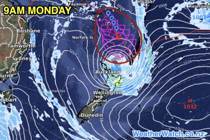
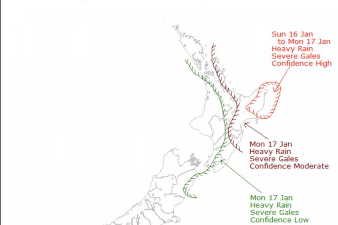
The Bay of Plenty is an area potentially at risk of a direct hit from Cyclone Cody with new modelling showing the storm hitting New Zealand late on Sunday and across Monday, with more precise predictions expected Friday.
A direct hit refers to where the centre of the storm is and the severe weather portion of the storm looks to be more widespread with the East Cape, Gisborne and potentially Coromandel Peninsula and Great Barrier Island also at risk.
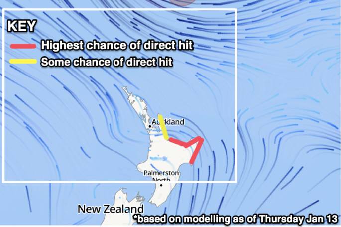
Based on IBM data and long range modelling WeatherWatch.co.nz now says the North Island currently has a moderate to high chance of being directly impacted by severe weather generated by Cody from Sunday evening to Tuesday morning.
Cyclone Cody is now leaving the tropics and will soon lose its "tropical" portion, and will be known as Ex-Cyclone Cody.
"We're still another day or two from being more precise about where the centre of Cody may track" says WeatherWatch.co.nz head forecaster Philip Duncan.
"Based on data and modelling from the past few days it shows severe weather risks from Cody are possible across the northern half of the North Island and the eastern half of the North Island later Sunday and across Monday, maybe early Tuesday".
Philip says detailed forecasts at RuralWeather.co.nz and WeatherWatch.co.nz are already showing rainfall minimum totals of 50 to 70mm in many parts of Coromandel Peninsula, Bay of Plenty, Gisborne and East Cape along with east to south east gales in exposed areas.
"The main issue with being specific just yet is that the storm is tracking north to south and NZ is shaped north to south too.
'This means if Cody's future tracking shifts, even just slightly westwards, it puts more parts of the North Island, including Auckland, in the risk zone. But if it tracks further east then severe weather may shift further to sea".
MetService today takes responsibility for Cyclone Cody as it tracks out of the tropics and towards New Zealand's North Island.
There Severe Weather Outlook (SWO) can be found here. This map will be updated again mid this afternoon some time (and is updated daily in the afternoons).
MetService is expected to issue Weather Watches and Warnings on either Friday or Saturday.
Both MetService and WeatherWatch.co.nz will be able to be more specific about risk areas and more precise in tracking tomorrow.
MetService is asking people to share this information about Cyclone Cody with family and friends as many are still holidaying at beaches and camping sites.
'Though Cyclone Cody will no longer be a Tropical Cyclone by the time it affects New Zealand, this doesn't mean it will have lost any of its sting," says MetService Meteorologist April Clark.
"Currently the exact path Cody will take over New Zealand during Sunday and Monday has significant variability, but it is clear that the upper two-thirds of the country will see some form of severe weather from the system and the north and east will get large swell.”
If you're camping or away on holiday and have further questions for now please refer to your hyper-local RuralWeather.co.nz or WeatherWatch.co.nz forecast for more details along with the MetService SWO.

0 comments
Leave a Comment
You must be logged in to make a comment.