A new high pressure zone is smack bang over the top of New Zealand this weekend bringing lighter winds and a lift in temperatures, says a WeatherWatch spokesperson.
'Many places that had temperatures cut right back in recent days will have that reversed. Southland and inland Otago today will be in the mid to late 20s with some places over 30 degrees.”
Northern New Zealand is the same although Saturday may still be a little cooler for some.
'More often than not there is about a 12 to 24 hour lag with temperatures in the North Island compared to the South Island, so Sunday and Monday may be hotter in the north,” says a WeatherWatch spokesperson.
'The high means mostly dry weather but a few afternoon downpours are possible, even an isolated thunderstorm in Northland today.”
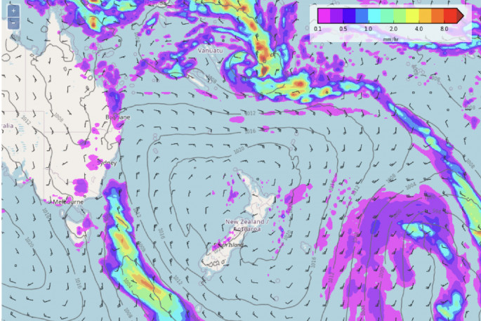
There is also a high risk of a tropical cyclone near Fiji by Monday.
'As WeatherWatch.co.nz has been mentioning since the end of 2021, there is a strong chance of a tropical storm forming directly north of New Zealand in the start of January,” says a WeatherWatch spokesperson.
'Powerful high pressure in the NZ and Tasman Sea areas have been limiting the growth and movement of tropical lows, but that shifts a bit early next week.”
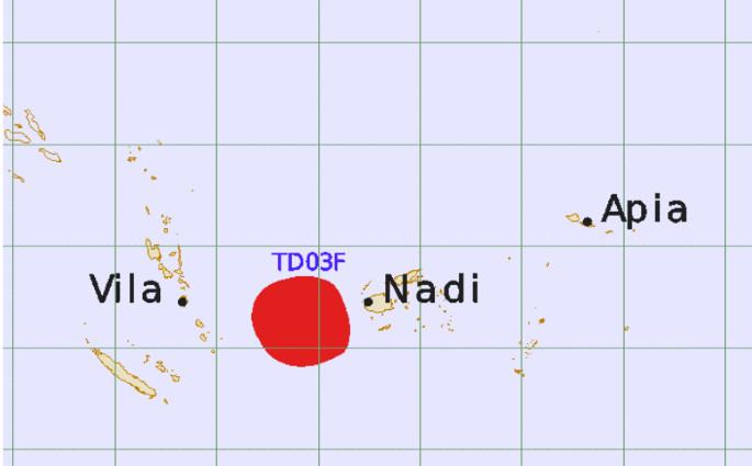
The team at Fiji Met Service say there is a "moderate to high" chance of a tropical cyclone forming on Monday between Vanuatu and Fiji and lingering a few days there.
WeatherWatch.co.nz says that NZers should be monitoring this as it may impact us.
'Our long range January ClimateWatch update said northern NZ could get a heavy rain event - but that there was a very fine line between very dry weather and very wet weather in this set up. This still remains the case,” says a WeatherWatch spokesperson.
'If this tropical low does hit the North Island it will bring much welcome rain to very dry areas - and sorry campers, maybe one day of rain too.
'If it misses the North Island it may mean dry weather carries on - breaking the long rang forecasts and encouraging the chance of water restrictions.”
WeatherWatch say that this is a classic example of the tough nature of weather forecasting in NZ when we need a single rain event to "fix" how dry it's becoming.
'The narrow north-to-south nature of NZ means tropical rain events like this can make a direct hit - and just as easily miss us as they get pushed a little further east,” says a WeatherWatch spokesperson.
'We'll have more details on this on Sunday and the coming days. This is one to keep up to date with as even if it misses NZ weather-wise it may bring deadly rips, currents and waves to some beaches.”
WeatherWatch also say that a cooler change may be coming.
'Not everyone has hot summer weather for the next week ahead. A new high pressure zone moves back into the NZ area from the Southern Ocean/Tasmania area next week - and much like the past few days it brings a light southerly change that sees temperatures drop, even though no other major weather changes,” says a WeatherWatch spokesperson.
Next week Dunedin has a number of days with highs between 14 and 17 degrees Celsius forecast. So too does Invercargill and other coastal areas of Southland and Otago.
'It's not just the South Island either,” says a WeatherWatch spokesperson.
'By late next week it's expected that Hawke's Bay and Wairarapa may see ten degrees shaven off their daytime highs, going from the mid to late 20s for the start of the week, down to highs in the late teens by Thursday.”
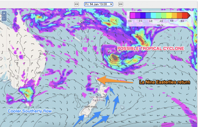
The weather forecast from WeatherWatch six days from now on Friday January 14. Image: WeatherWatch.

0 comments
Leave a Comment
You must be logged in to make a comment.