Temperatures in eastern parts of the country are expected to yo-yo this week, with warm days forecast today and Tuesday ahead of a cool change on Wednesday, before temperatures rebound later this week.
A front that brought heavy rain and thunderstorms to northern and western parts of the country during Sunday and Monday morning has now moved away to the east and is followed by an unsettled west to northwest flow.
"The northwest flow is responsible for pushing daytime temperatures into the mid-twenties in some eastern areas today and Tuesday. Napier and Hastings are headed for 24 or 25°C, while parts of Canterbury are expected to reach 23°C," says MetService meteorologist Peter Little.
"These warm daytime temperatures make the atmosphere more unstable, and where winds converge showers or even thunderstorms may develop. Showers and thunderstorms are possible in Canterbury this afternoon, which have the potential to produce localised heavy rain, hail and strong wind gusts."
Another front moves onto the south of the South Island from the Tasman Sea on Tuesday morning, then weakens by the time it reaches the North Island on Wednesday.
However, the southwest flow following the front does bring cooler temperatures, knocking around 10 degrees off the daytime maxima in the previously warm eastern areas.
"A maximum temperature around 15°C is forecast for Hawke's Bay on Wednesday, and 13°C for Christchurch. That will be around 10 degrees colder than Monday and Tuesday, so will require a completely different wardrobe."
A ridge of high-pressure spreads over the country on Wednesday, then persists through to the weekend.
This ridge brings fine weather and light winds to most places, along with warmer temperatures.
The flies in the ointment are areas of morning drizzle, and afternoon heat showers inland.
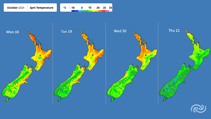 Image: MetService.
The ridge moves to the east of New Zealand on Friday, which allows northeast winds to develop.
Meanwhile, a low-pressure system and an associated front is expected to deepen over the North Tasman Sea.
"A weather system is poised to bring rain to northern and western parts of the country for a time over Labour weekend, so folk planning outdoor activities for the long weekend are advised to keep up to date with forecasts."

0 comments
Leave a Comment
You must be logged in to make a comment.