.jpg)
This past week has followed the trend for the month of May, which has proven to be well below average for many places around the country in terms of rainfall but with warmer and well above average daytime temperature.
'The temperature in Wellington hasn't dropped below double digits since Monday morning, and is not expected to drop below 13 degrees this coming week,” says MetService meteorologist Kyle Lee.
'Today's maximum temperatures across the country aren't expected to be below 14-15 degrees for the main centres, well above average for most of the South Island.”
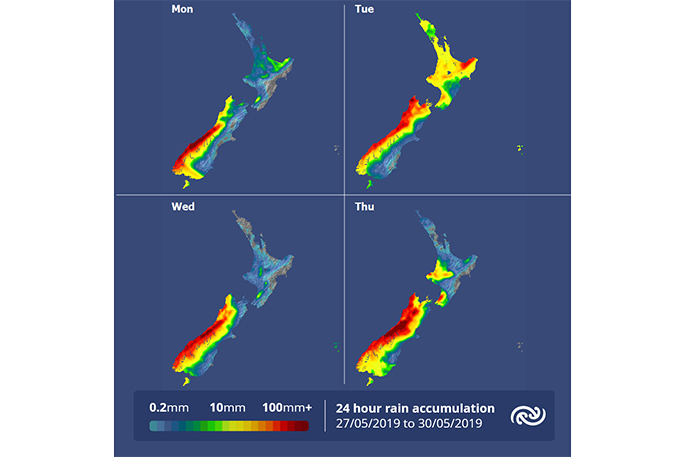
Not all the country is seeing settled weather though as MetService currently has Heavy Rain Watches and Warnings in force for Fiordland, the headwaters of Otago Lakes and Rivers, and Westland south of Otira, with thunderstorms also expected in these areas.
This week there will be a return to a more autumn like pattern with northwesterly winds and a few significant fronts moving onto the country. These fronts will bring rain as well as strong winds to most places.
The west coast of the South Island will especially be affected as it will see a prolonged rain event from today.
'This could be a significant rain event and rainfall accumulations are likely to exceed 500mm in some places over a four- or five-day period,” says Kyle.
'Towards the end of the week, as we approach the official start date of winter, we are in line to see more fitting weather as cold southwesterlies are set for New Zealand.”
Understanding MetService's Severe Weather Watches and Warnings:
Outlooks are about looking ahead:
• To provide advanced information on possible future Watches and/or Warnings
• Issued routinely once or twice a day
• Recommendation: Plan
Watches are about being alert:
• When severe weather is possible, but not sufficiently imminent or certain for a warning to be issued
• Typically issued 1 - 3 days in advance of potential severe weather.
• During a Watch: Stay alert
Orange Warnings are about taking action:
• When severe weather is imminent or is occurring
• Typically issued 1 - 3 days in advance of potential severe weather
• In the event of an Orange Warning: Take action
Red Warnings are about taking immediate action:
• When extremely severe weather is imminent or is occurring
• Issued when an event is expected to be among the worst that we get – it will have significant impact and it is possible that a lot of people will be affected
• In the event of a Red Warning: Act now!

0 comments
Leave a Comment
You must be logged in to make a comment.