A front which raced across the South Island this morning continues up the North Island this afternoon and evening.
It has not only brought rain to the country, but this front will also initiate a change to cooler temperatures this week.
'Around 150mm of rain was recorded over the southern Westland ranges this morning along with gale northwest winds about Canterbury High Country as an active front crossed the South Island," says MetService meteorologist April Clark.
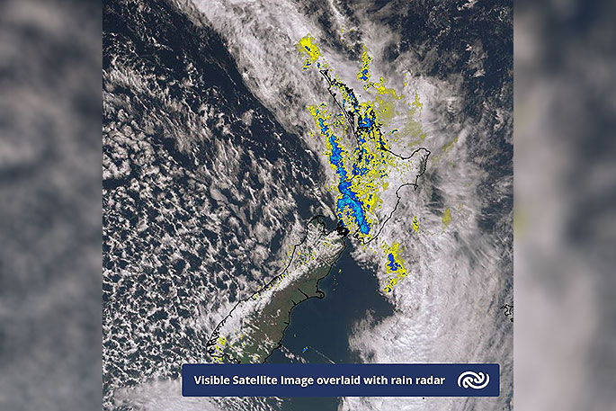
'This active weather system is set to continue north, spreading a period of heavy rain over western and northern areas of the North Island today (including Auckland).
"These areas are also under risk of localised thunderstorms this afternoon and evening with rain intensities of up to 25mm per hour, potentially impacting on the school pick-up and the evening commute for Aucklanders."
Eastern Bay of Plenty and the Gisborne ranges will be the last to see heavy rain clear early Tuesday as the front weakens and moves away to the east.
Behind the front, rainfall significantly decreases (if not ceases), but so will temperatures nationally. Eastern coasts will see the greatest drops with uninterrupted southerlies dragging cool air from the Southern Ocean.
Some inland areas may even see early morning frosts with Blenheim's overnight temperature on Wednesday set to drop to 3C, the lowest since November.
This cool change is set to last over the country for the rest of the week.
While a ridge of high pressure starts to build over the South Island and western parts of the North Island on Tuesday, bringing dry weather, the east and upper North Island is set to hold onto a few showers in the southeast flow.
'During Thursday and Friday another front is forecast to sweep across New Zealand, cementing a cooler and changeable weather pattern which is typical at this time of year,” says April.

0 comments
Leave a Comment
You must be logged in to make a comment.