Cyclone is Oma is again a Severe Category 3 tropical storm in the Coral Sea but there is now finally increasing confidence Oma will not directly hit New Zealand and will weaken in the days ahead.
It's been a long time coming but finally forecast computer models are aligning to suggest Cyclone Oma won't directly hit New Zealand, says WeatherWatch.co.nz.
"Instead, may offer some help at creating an even larger low in the NZ area. To make it more confusing, news chatter about a tropical storm may now shift to talk of a cold wintry-like snap...but yes, it's all somewhat connected."
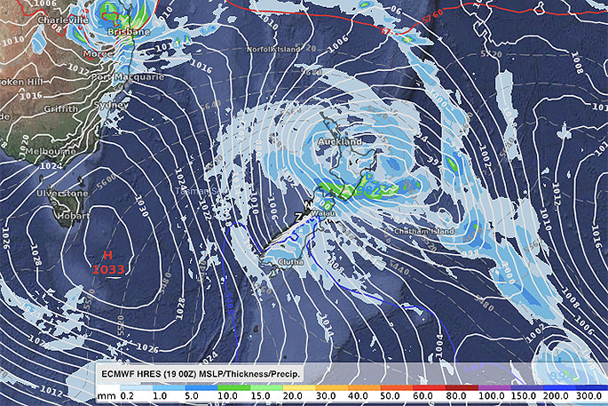
ABOVE - ECMWF for Sunday afternoon.
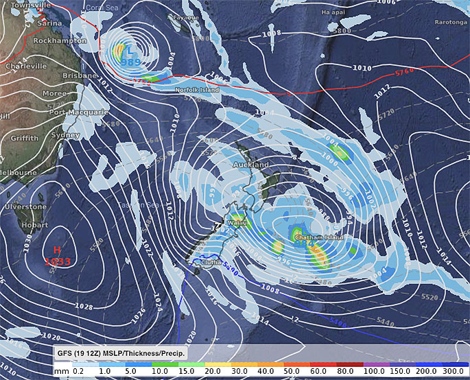
BELOW - GFS for Sunday afternoon.
What has changed?
For the first time in many days the various reliable forecast computer models started to align and while not in complete agreement about the future tracking of Oma they are all showing the system is less likely to directly barrel in to the country.
"Previously some models were in complete disagreement. The latest thinking is that the high pressure system in the Tasman Sea will push it back to the north - it may still impact Australia, or it may remain at sea," says the weather organisation.
What does this all mean for NZ?
Cyclone Oma is a big area of low pressure and is pulling down a lot of tropical energy closer to New Zealand.
At the same time a high east of NZ this week and weekend will work alongside Oma to pull down more sub-tropical nor'easters.
So while Oma isn't likely to directly hit NZ, it may help fuel energy into a new system that is coming out of the Southern Ocean.
"We expect a large area of low pressure to form over New Zealand this weekend and it may deepen rapidly to the east, creating heavy rain and gales in some areas - but not all."
Why are we going from talking of a Tropical Cyclone to a "Wintry Blast"?
One of the few things the various forecast computer models did actually agreed on was the fact a cold southerly was coming in this Friday and weekend.
WeatherWatch.co.nz says if Oma doesn't directly hit NZ then Oma doesn't bring with it the very humid hot tropical air - instead the southerly that was forecast originally looks most likely to dominate but will form a new low that will cover most of the country on Sunday.
Is a Storm coming to NZ?
A very large area of low pressure should form this Sunday and engulf much of the county. It will be deepening quite quickly too.
There is an unpredictable nature about large, rapidly deepening lows and they can create pockets of severe weather (Gales, heavy rain, big seas) but also large areas of calm and dry - some people may have a fairly pleasant weekend weatherwise despite severe weather possibly in nearby regions. We need a few more days to fine tune now.
Does Cyclone Oma bring any threat at all for NZ, or is it definitely avoiding us?
Yes there still is some threat but it's fading more with each day. Probably a 25 per cent risk that it could still slip north of NZ and brush northern regions. 75 per cent of the data supports Oma remaining separate to any of the lows over NZ and being pushed away from us this weekend.
Where will severe weather most likely be this weekend?
This will still need to be locked in, but if a deep low does form just east of central NZ it could create gale easterlies on the West Coast, heavy rain on the east coast and lower North Island and may be some heavy rain in northern NZ where it has more tropical energy.
Any warnings will be issued by Government forecaster MetService and they would likely be issued later this week or Saturday - but won't be issued until forecasters can clearly lock in the size, depth and precise location of the new low being created.
Will we get soaking rains?
"Again, until we know the size, depth and precise location of the new low being created this weekend it's hard to lock in rainfall. Generally most regions should get some rain - but whether or not it's enough to help reverse any big dry it's harder to lock in yet.
"We hope to have more details in the next couple of days. We don't expect everyone will get heavy rain."
How cold will it be?
Some parts of Southland, Otago and Canterbury this Sunday/Monday will experience daytime highs up to 20 degrees lower than where they were a recently. Highs of just 11 to 14 degrees are possible for a time.
"Cooler air will move in to the North Island too, but perhaps not so dramatically. However overnight lows in Auckland tomorrow night will be around 21 degrees, but by next Monday it may be 8 degrees lower."
Will Cyclone Oma hit Australia?
There is some chance Brisbane / Queensland coast may be impacted by Oma early next week if the storm does get pushed back northwards.
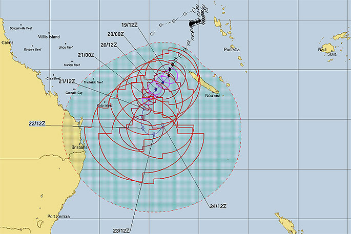
- Tracking by JTWC (US Govt)

0 comments
Leave a Comment
You must be logged in to make a comment.