Areas of rain are coming to New Zealand but the jury remains out on whether or not Cyclone Oma will directly impact the country this weekend and early next week.
As hundreds of computer models continue to try and crunch the data the globe's two most trusted sources for cyclones, GFS and ECMWF are still totally disagreeing about Oma's future track beyond the northern Tasman Sea this Friday.
GFS still picks the tropical low directly affecting New Zealand while ECMWF shows Oma doing a complete U turn and reversing back into the tropics this weekend, says WeatherWatch.co.nz
"But both these main models, and many others as well, are picking a new low to form around New Zealand regardless of Oma's precise tracking.
"This means a large new low with some connections to the tropics and cold air from the Southern Ocean will help produce a sizeable low pressure system bringing rain to both islands... but where, how much and when still cannot be locked in due to so much chaos.
"There is also the possibility the bulk of rain could fall at sea around New Zealand but not so much overland."
Due to the big uncertainty around Oma's precise track rainfall totals are not yet known. It may be windy and wet enough to prompt severe weather warnings in both islands, or it may push more offshore, says WeatherWatch.co.nz.
But as WeatherWatch.co.nz said last week, expect changeable forecasts as we all try to fine tune the messy data and work out who has drizzle, showers, rain, heavy rain and who may miss out.
Rainfall-wise, nothing is yet confirmed and there are many variables. This is quite a complicated set up.
WHAT IS LOCKED IN...
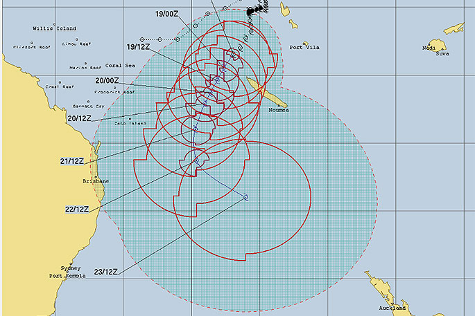
Cyclone Oma will track past New Caledonia today and tomorrow bringing a lot of rain and possibly damaging winds to the north western tip of the island. Oma is likely to remain a strong Category 2 storm but the further south it tracks the less favourabole the conditions are for keeping it a tropical cyclone. Oma will likely peak tonight before starting to very slowly weaken from Wednesday onwards.
Oma will track from the Coral Sea to the Tasman Sea around Friday and this is when the computer models still disagree about where Oma goes next...on to New Zealand as an extra-tropical low, or does the edge of Oma's flow help generate an entirely new low over the country as a big southerly arrives this Friday and weekend?
What is known is that some type of new low will form around the New Zealand area this weekend but with so much chaos we can't be specific about how much rain will fall, where and when as of today. The area of low pressure that forms may be quite large which can actually make it harder to lock in, not easier, due to large areas of dry among the rainclouds.
"The main southerly arrives Friday and this weekend and the new low forms around NZ this weekend. Data we trust has been wildly flip flopping between heavy rain for New Zealand and less than normal amounts for this time of year - so rainfall over the weekend and next week actually remains quite unknown still, which won't be a great deal of help for those who are very much in need of rain.
"While we talk about GFS and ECMWF there are literally hundreds of weather computer models and IBM, who we are partnered with, has New Zealand's most powerful weather super computer which we have exclusve access to and is used to make up your local 10 day forecasts here at WeatherWatch.co.nz.
"This IBM super computer crunches all the forecast modelling in the world along with other trusted data so we suggest you keep up to date with your local 10 day forecast, including the hourly chance for rain, wind speed etc, to help fine tune the confusing set up this weekend and early next week and make sense of it more on a local regional level for you."
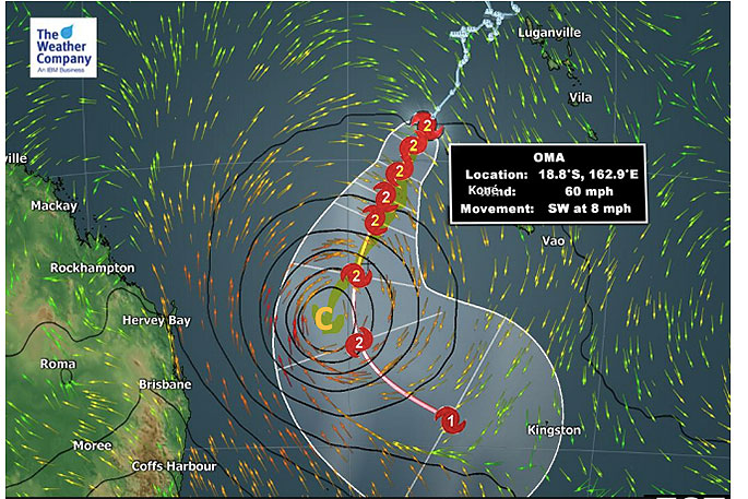 The "C" shows where the cyclone will be this Saturday based on ECMWF, while the tracking with the Category numbers is the GFS plot. Either way it shows consensus up until about this Friday night/Saturday, then the models disagree about what happens next. But regardless the data suggests some rain is coming to dry parts of New Zealand this weekend.

1 comment
Chaos
Posted on 19-02-2019 11:03 | By morepork
I'd really like to have a chat with the Amazon butterfly that flapped its wings and caused all this...
Leave a Comment
You must be logged in to make a comment.