MetService is forecasting a few weakening fronts and troughs to move northwards over New Zealand today and Friday, ahead of a ridge of high pressure building from the south and bringing the fine weather back across Aotearoa this weekend.
However, some well needed rain is forecast across much of the North Island from Monday.
'Northwesterly winds until late Friday will bump temperatures in the east up, with the mercury in Hawke's Bay and Gisborne possibly hitting the 30s on Friday," says MetService Meteorologist Rob Kerr.
"Western parts of the North Island will see some showers and a possible thunderstorm on Friday morning.”
The cooler change will cause temperatures to drop a few degrees over eastern parts of New Zealand on Saturday.
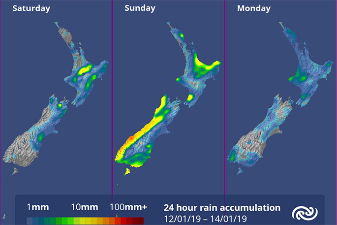
The warm, moist northwesterlies ramp up again over southern and central parts of New Zealand on Sunday, again driving up temperatures in the east and bring rain to the west with the heaviest falls around Fiordland and the West Coast.
'This front is expected to sweep north over Auckland and Northland on Monday, bringing scattered rain to the upper North Island.
"The cooler, drier air behind it should bring respite from the muggy nights at the start of next week."
Good conditions are forecast for the last two days of the ASB Tennis Classic in Auckland on Friday and Saturday and the T20 Black Caps match against Sri Lanka also in Auckland Friday evening, with south west breezes and temperatures peaking at 27°C.
To get the most up to date information on severe weather around the country, or any other forecasts, see metservice.com or on mobile devices at m.metservice.com, or download the MetService App. You can also follow our updates on MetService TV, at MetService New Zealand on Facebook, @metservice and @MetServiceWARN on Twitter and at blog.metservice.com

0 comments
Leave a Comment
You must be logged in to make a comment.