Thundery weather is moving across the Bay of Plenty hard and fast, so don't expect it to stay long.
MetService Metoroglist Angus Hines says it is a fairly active situation over the central parts of the North Island at the moment, including much of the Bay of Plenty.
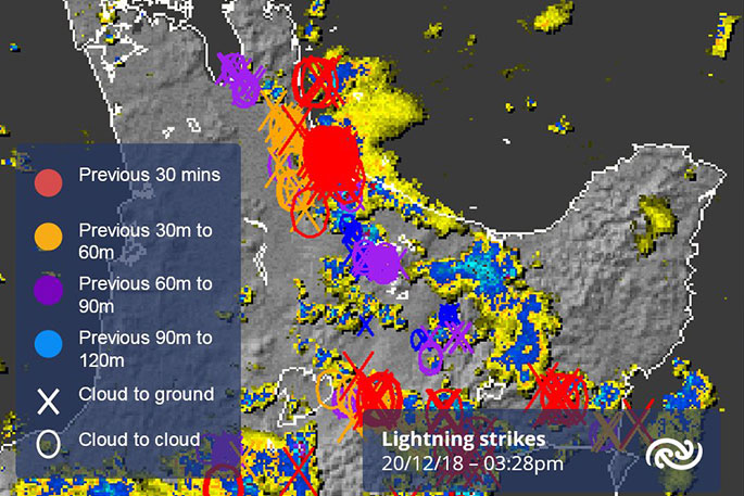
'We have some heavy showers and isolated thunderstorms right through the region, as it happens the one that is the heaviest at the moment is just passing over Tauranga now.
'There will be some intense rainfall rates as well as quite a lot of lightning in that part of the country at the moment.
'All the weather, is moving eastwards and it's moving relatively rapidly so I wouldn't be expecting the intense rainfall rates to last for very long. That will be clearing away and moving to more eastern parts of the Bay of Plenty quite quickly.
'For the rest of this evening, we still do have some risk of some more heavy showers. I can't rule out there being another thunderstorm somewhere around Tauranga, there are a few more showers in line for this evening but the general trend will be for that activity to be easing particularly once the day starts to cool down,” says Angus.
Looking at the weather for tomorrow, it will be a bit more settled.
'There will be a couple of early showers, potentially just lingering from what we are experiencing this evening, along with some morning cloud,” says Angus.
'There will be some decent spells and some fine weather, some good sunshine with just a couple of some isolated showers popping up around the region in the afternoon. It will be fairly hit and miss and it's not expected to get everyone tomorrow.
'It's not expected to be as intense as this afternoon and this evening,” says Angus.
Some intense Thunderstorms around BOP right now - one overhead in #Tauranga. Follow here: https://t.co/BmvSvfEaLb ^AH pic.twitter.com/yAI2pWG5LP
— MetService (@MetService) December 20, 2018

0 comments
Leave a Comment
You must be logged in to make a comment.