Rising water levels in White Island's crater lake could cause an overflow by mid-2019, according to GeoNet.
The prediction has been made amongst recent observations by GeoNet volcano information specialist Brad Scott.
'The water level in the crater lake at White Island (Whakaari) has risen around 10 metres so far in 2018. If it continues to rise at the same rate it will start to overflow around mid-2019,” he says.
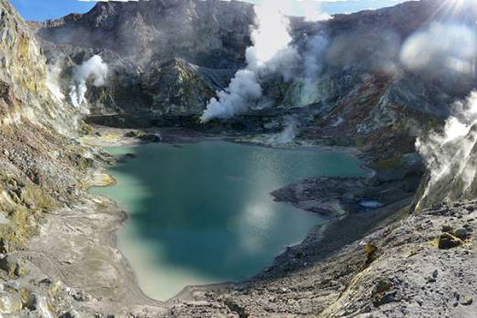
Brad says the crater lake at White Island has been steadily growing since a small lake became re-established in January 2018.
The previous lake was destroyed following an eruption in April 2016 and excavated the crater floor by about 13 metres.
'The lake has risen in a similar fashion three times in the last 15 years, coming close to, but never reaching overflow. In February-March of 2006 the lake got to within about one metre of overflow, before receding as the lake heated and evaporated.”
A recent volcanic alert bulletin revealed the growing crater lake could cause hydrothermal surface activity as it drowns some of the vents or fumaroles near the lake.
'Drowning of the vents has led to steam-driven activity – geysering – however, most vents seem to have ‘drowned' relatively quietly. This process is not over yet, with some vents still steaming away above lake level.”
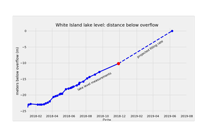 Plots showing the crater lake filling rates. The red dot is the current water level.
The overflow of the lake has the potential to pose a danger to people visiting the island.
'This danger relates to a large stream flowing across the Main Crater floor. The danger is mitigated, however by the low probability of the lake outlet failing and a flood occurring.
'Aspects of these hazards were examined in 2005 by GNS Science. We will continue to review as the lake refills.”
Because of the terrain and geology of the ground the team uses web camera images and measurement techniques to measure water level.
'The first technique uses a topography model derived by drone imagery when the lake was not present.
'We identify the area drowned and calculate the depth or water level rise. The other uses the measurement of distances below a target on the crater rim on our web camera images, from which we can calculate a water level.”
The rising levels are due to two factors including the condensing of volcanic steam and gas from vents under the lake; and the amount of rainfall into the lake catchment.
'Based on our calculations and analysis of water samples, we estimate about 75 per cent of the fluid comes from condensing steam vents under the lake. The rest comes from rainfall, which means rain has caused about 2.6 metres of the water level rise.
'Importantly, there is no substantial change in the level of volcanic activity at White Island. Crater lakes have formed in the past and we do see changes in the geothermal activity associated with this, but no signs of increased volcanic unrest.”
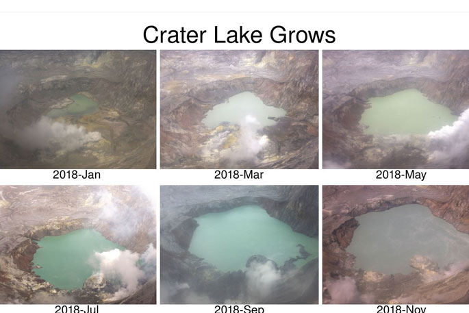
A montage of images from the West Rim web camera showing how the Crater Lake has been growing since January 2018.

0 comments
Leave a Comment
You must be logged in to make a comment.