An area of low pressure is today dropping from the sub-tropics into the upper North Island and while very small in size it does pack a bit of a punch as it works in conjunction with a blocking high pressure system further south.
WeatherWatch.co.nz head forecaster Philip Duncan says this large high will do two things to the low.
"One it will slow down the movement of very isolated but quite intense rain which may lead to localised flooding, and two it will increase the squash zone of air pressure between the low and the high, in other words making for stronger easterly quarter winds which will reach gale force.
"As we mention below, the area with the heaviest rain is quite isolated but also serious enough to monitor."
Philip says to make matters more confusing, this small low could move in a couple of directions over the next 24 hours which greatly affects where this small but heavy burst of rain may track.
"Due to higher uncertainty than usual with forecasts we advise people to stay up to date with all forecasts, warnings and the latest outlooks as some changes are likely."
MAIN HIGHLIGHTS:
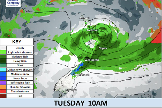
- A developed low originating from southern Pacific Ocean (sub-tropics) is now approaching the northeastern coast of New Zealand's North Island, bringing the risk of heavy rain and gales from late Monday and across parts of Tuesday.
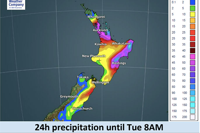
- The intense rain band in the southern side of the low will spread over the upper North Island. Heavy rainfall may start on Monday afternoon or evening in Auckland, Coromandel Peninsula, Bay of Plenty, Gisborne and Hawke's Bay but the main area of concern is actually quite small.
- From Monday night through Tuesday rain is more likely to occur in Gisborne and Hawke's Bay, where total rain accumulation is expected to above 150mm in places. Again, the heaviest downpours look to be in quite small isolated pockets down the eastern coastline.
- The low will also bring gales with higher gusts along the northern and eastern coastlines of the North island from Monday night. The highest risk is in the eastern part of Bay of Plenty where strong east to southeast winds may exceed the speed of gale force (63 km/h) until Tuesday morning.
- From Tuesday to Wednesday morning, heavy rain and gusty winds are expected along the eastern coastline from Gisborne to Marlborough.
- For many in the west and even though near this rough weather conditions may be fairly "standard".
- Note that there is still considerable uncertainty in the forecast track of the heaviest rain - but it appears to be in a narrow area that should brush the north eastern North Island later today - but gets more complicated about where it will precisely track beyond Tuesday morning. There are both possibilities that the low pressure advances southward along the eastern coastline from Gisborne, or, advances southwestward across the central North Island.

1 comment
Oh gosh soooo much rain
Posted on 11-06-2018 15:35 | By Crash test dummies
Better keep the ball rolling on all this and evict another 100 or so residents out of their homes this afternoon just in case there is a bit of rain?
Leave a Comment
You must be logged in to make a comment.