The main southerly blast is moving up the North Island now after bring low level snow, even sea level snow briefly, to parts of the South Island last night.
"Snow may now affect North Island highways later today and into Thursday morning, especially SH1 the Desert Road and SH5 the Napier to Taupo highway," says WeatherWatch.co.nz head forecaster Philip Duncan.
"Hail showers to sea level are possible in both islands as the cold change sweeps through".
Philip says by Thursday frosts return to the South Island interior but the daytime highs do start to lift - while Thursday looks to be the North Island's coldest day this week.
"By Friday most places are back to 'normal' under a big high. That high looks to dominate the North Island this weekend and will encourage slightly warmer westerlies over the South Island."
Main highlights:
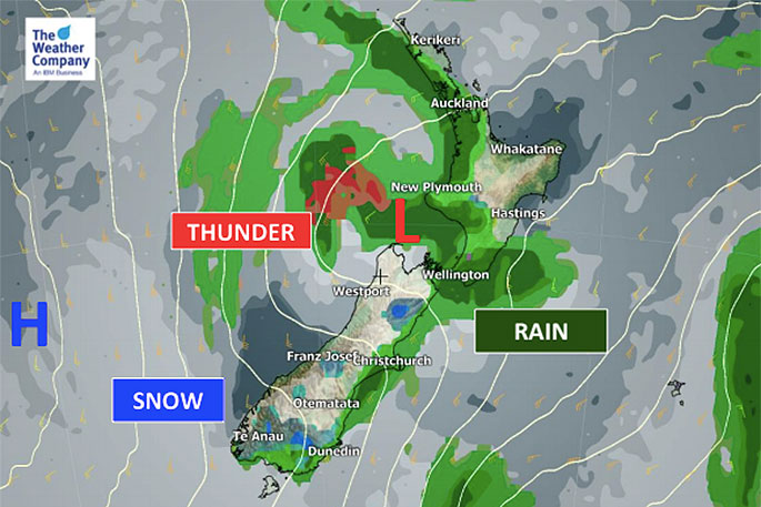
- A low associated will slowly cross in the North Island today followed by a colder southerly flow, heavy showers and hail to sea level.
- Localised heavy rain and isolated thunderstorms will be possible and winds may also be strong in exposed coastal areas.
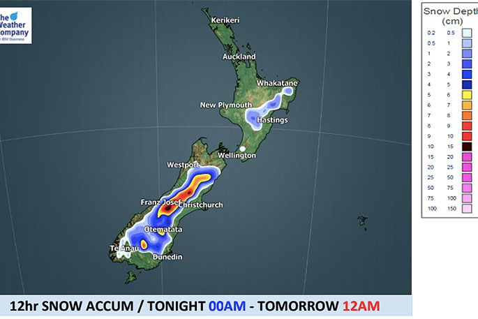
- Snow will continue to fall over the mountains and ranges of the South Island today, but the air flow is drying out slowly for them over the next 24 hours.
- Heavy snow will be possible in the high mountains in the South Island and snow may fall over most mountains in New Zealand for a time.
- Maximum temperatures will be below 10C in the plains of the South Island and will be 10-13C, even as far north as around Auckland.
- It may feel much cooler due to strong winds.
- On the other hand, minimum temperatures will be 4-8C in most areas tonight and may not drop into freezing level lower down due to winds or cloud cover. Frosts are most likely well inland.
- Temperatures of below 0C might be only in the highlands.
- There are risks of higher snow accumulations and big freeze across the mountains.
- Motorists should be taking extreme care tonight due to snow, ice and maybe black ice.
- From Thursday temperatures will actually return to average in the South Island and by Friday in the North Island - and it will continue this weekend as well. In fact next week may be warmer than average for some.

0 comments
Leave a Comment
You must be logged in to make a comment.