A severe weather warning issued for the Bay of Plenty has now been lifted, but the MetService is forecasting more rain for the region this afternoon.
A severe weather watch is in place for many areas around New Zealand, including the Coromandel and Bay of Plenty.
Fronts associated with a low over the Tasman Sea are forecast to move slowly southwards over the North Island today and overnight Monday, then to the east of the North Island Tuesday afternoon, bringing strong and cold southwesterlies over the country from late Tuesday to Wednesday, says the weather organisation.
The latest Severe Weather Watch has been issued. Details: https://t.co/bcFLKY4OUU . The low to the northeast of NZ still bringing a risk of heavy rain to parts of #NZ & another weather system approaching from the south bringing risk of heavy snow and wind from Tuesday evening.^CF pic.twitter.com/Hne6A0Sjed
— MetService (@MetService) June 3, 2018
'The fronts and low are forecast to bring further heavy rain and isolated thunderstorms to northern and eastern parts of the North Island during today and Tuesday.
'The watch is for the possibility of rainfall amounts reaching warning criteria in Northland, northern Auckland, Great Barrier Island, Coromandel Peninsula, Bay of Plenty, northern Gisborne and eastern Marlborough through to Tuesday morning.
'The Watch is also for the possibility of south-southwest winds reaching severe gale strength about coastal Clutha and Dunedin from Tuesday evening to early Wednesday morning.”
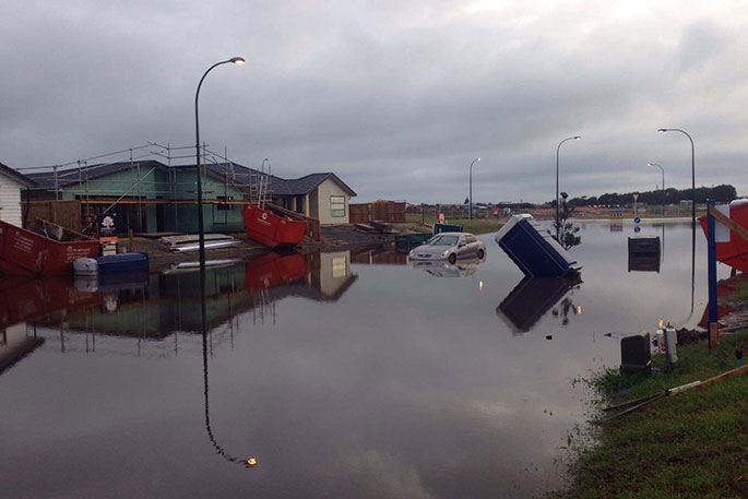
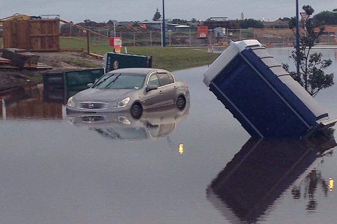
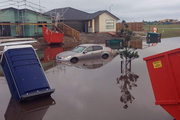
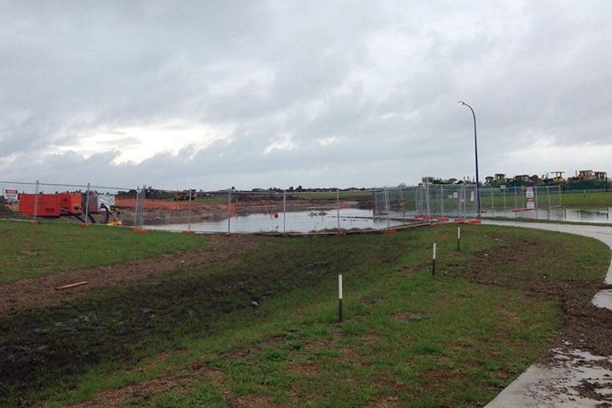
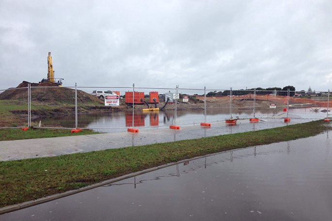
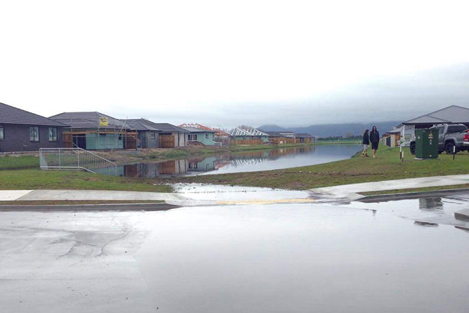
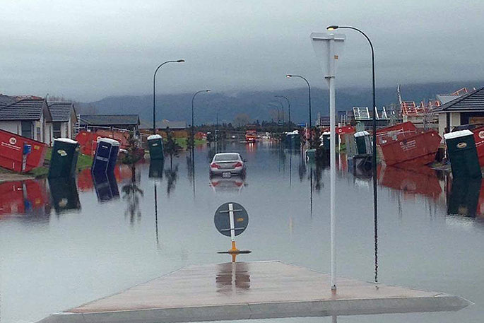
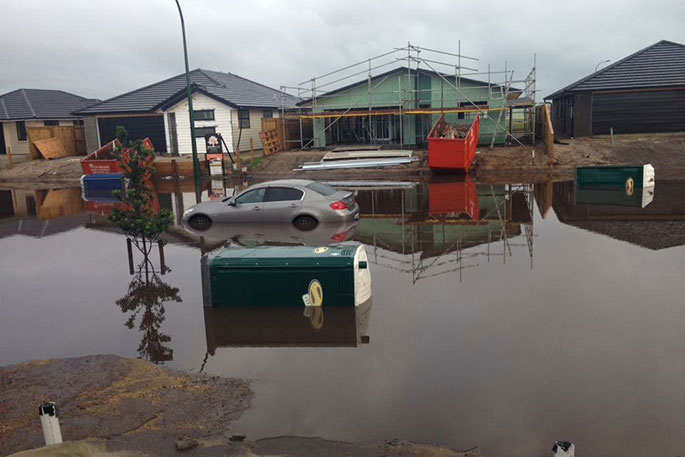
Overnight, the Western Bay of Plenty was pummelled with heavy rain causing widespread flooding throughout the region.
Walking around Papamoa this morning, Marie snapped a few shots of the flood in the daylight.
'There are lots of people out and about taking photos. I'm glad the stormwater reserves and road are doing what they were designed for,” says Marie, 'taking the excess water and not flooding our brand new homes. They haven't finished the stormwater system yet but the waterways saved our homes.”

5 comments
Looks like the Tauranga City Council
Posted on 04-06-2018 11:48 | By The Caveman
Has more problems ! Clearly the storm water drainage is WELL below what is required in the new subdivisions at Papamoa
New infrastructure
Posted on 04-06-2018 12:43 | By maildrop
It doesn't bode well that brand new infrastructure cannot cope with a bit of rain. It will only get worse.
If you read the article
Posted on 04-06-2018 19:43 | By Calm down
The storm water system hasn't been finished yet and it's actually the design of the road that has prevented the houses from being flooded.
Hay @ Calm down
Posted on 04-06-2018 23:10 | By The Caveman
I am VERY familiar with the are where the flooding has occured. 55 years ago is was ALL farmland & one good "rain storm" in May/June resulted in the WHOLE area being under water for the rest of the Winter. The whole Papamoa area - inland from the coastal sand dunes is essentially COASTAL SWAMP The bottom line is that it's about 1-2 meters (MAX) above sea level, and a rain dump like yesterday is NEVER NEVER NEVER going to be drained away (ESPECIALLY if it's HIGH TIDE on the coast). The REAL BIG PROBLEM is that the TCC has granted developers resource consents to build on low lying SWAMP LAND, that has NO chance of any efficient storm water drainage. Looks like another Bella Vista problem for the council. Consents given - that NEVER should have been give
Never say never
Posted on 05-06-2018 14:19 | By Calm down
There's always a way, you could put pumps in the storm water network to pump away water that won't drain away fast enough.
Leave a Comment
You must be logged in to make a comment.