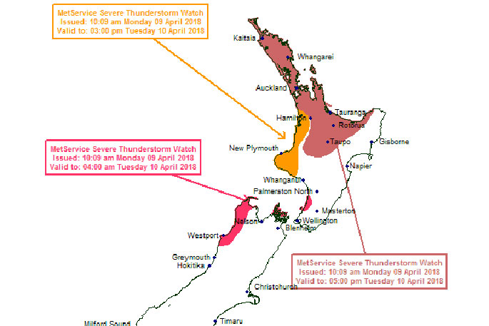
A severe thunderstorm watch has been issued for the Bay of Plenty.
An active trough is expected to move east onto these areas Monday evening and overnight Monday, says the MetService.
'This trough is likely to be accompanied by squally thunderstorms, possibly bringing wind gusts of more than 110 km/h and localized damaging tornadoes.
'Wind gusts of this strength can cause some structural damage, including trees and power lines, and may make driving hazardous. If any tornados occur, they will only affect very localised areas.”
Gales associated with the passage of this low are expected to affect the upper South Island and many parts of the North Island during Tuesday.
Severe gales are expected about northern parts of Westland and Buller, the Marlborough Sounds, Kapiti Coast and Horowhenua, Taranaki, Waikato, Auckland and the Coromandel Peninsula and a warning is in force for these areas, says the MetService.
'In addition, temperatures are expected to drop, with the snow level is expected to lower Monday night to 300-400 metres in the south and central South Island, and to 500-600 metres about the upper South Island.
'The largest snow accumulations are likely about Canterbury and Kaikoura and a Heavy Snow Warning is in place for these areas. Snow accumulations in Otago, Southland and Fiordland may not be as deep, but could still cause disruption and these areas are included in this Watch.”
Road Snowfall Warning issued for Desert Rd, Lewis Pass, Arthur's Pass, Porters Pass, Haast Pass, Lindis Pass... https://t.co/n45rwESNKk
— Severe Weather Info (@MetServiceWARN) April 8, 2018
Snow is also being forecast for the Desert Road.
'Rain is expected to turn to snow Tuesday evening, easing to showers Wednesday morning. From about 9pm Tuesday to 9am Wednesday expect 5 to 10cm to accumulate about the summit, with lesser amounts to 700 metres,” says the weather organisation.

0 comments
Leave a Comment
You must be logged in to make a comment.