A low pressure system approaching from the Tasman Sea, and a strong cold front approaching from the Southern Ocean are expected to come together to bring heavy rain, gale force winds and thunderstorms to many parts of the country, and heavy snowfall is also in the forecast.
A Severe Weather Watch has been issued for heavy rain for the ranges of Buller and northwest Nelson, as well as lower lying parts of Canterbury and Kaikoura Coast, starting late on Monday and continuing into Tuesday.
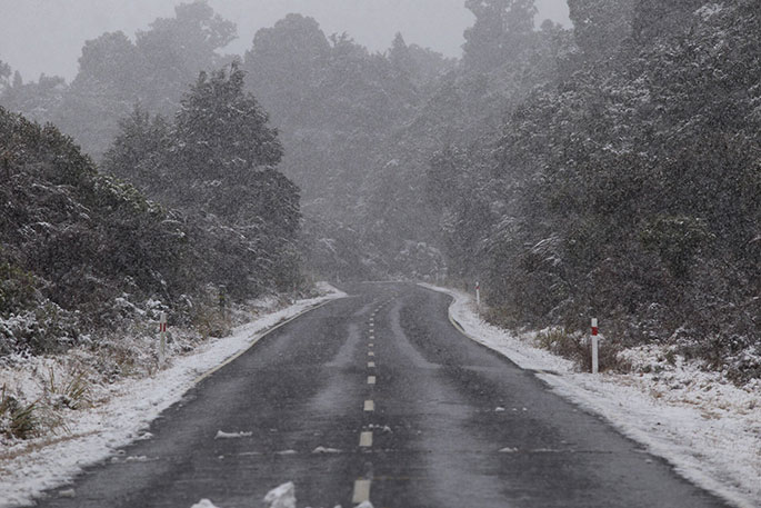
In addition, the first Heavy Snowfall Warning and Watches of 2018 have been issued for eastern parts of the South Island above 300-400 metres.
MetService meteorologist Claire Flynn says coastal towns and cities in the east of the South Island are likely to see heavy rain rather than snow, being too close to sea level, but she stresses that those who are planning on travelling will need to ensure they are on top of the latest weather updates.
'There are heavy snowfall warnings in place for the Canterbury High Country and Kaikoura Ranges above 400 metres, and snowfall Watches for Otago, Southland and Fiordland above 300 metres,” she says.
'In addition, road snowfall warnings have been issued for many of the alpine passes, with Lewis, Arthurs and Porters Pass expected to be worst affected, with up to half a metre of snow possible on Tuesday.
'Those closer to the coast will likely get heavy rain. While we may not see snow in Christchurch City, for example, higher roads of Banks Peninsula are likely to be affected by snowfall.”
Snow is also likely for the central North Island from Tuesday night and into Wednesday, and there is potential for Severe Weather Watches and Warnings could be issued for these areas as well.
Meanwhile, those further north in Auckland will not be exempt from the severe weather, with gale westerlies and squally thunderstorms possible on Tuesday.
'People need to read the forecast for their area, including the Severe Weather Warnings and Watches, and take steps to prepare if they are in the affected areas,” says Claire.
'Tying down trampolines, avoiding unnecessary travel, and clearing gutters are just a few steps people can take. There is the potential that the severe weather could disrupt power as well. If people are unsure where to start, there is good information on preparing for severe weather at the Get Thru website. You can also check current road conditions and closures on the NZTA website.”
The severe weather making its way to New Zealand will be here in time for the anniversary of another significant weather event in New Zealand history. Tuesday April 10 marks the 50th anniversary of the Wahine ferry sinking in Wellington Harbour, in what is now considered to be New Zealand's worst modern maritime disaster.
Those in Wellington taking part in Tuesday's commemorations will need to prepare for wet day, with rain becoming heavy at times, and cold southerly winds rising to gale in the morning.

0 comments
Leave a Comment
You must be logged in to make a comment.