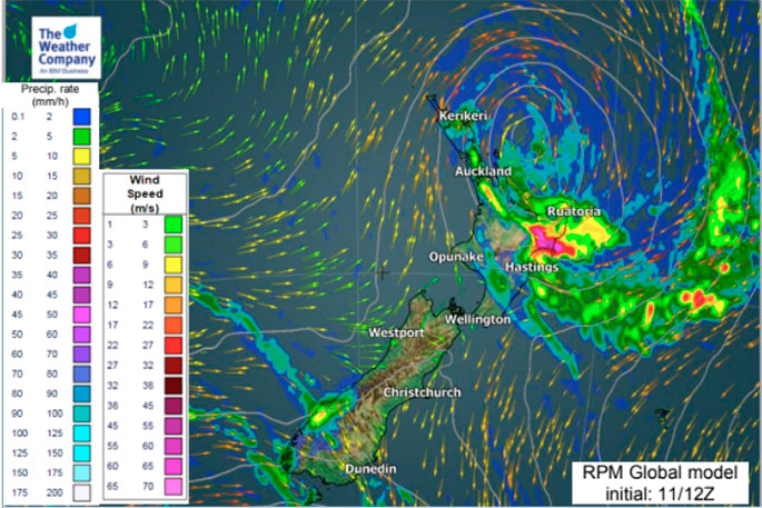
Cyclone Hola's transition into an extratropical storm is breaking up the portions of severe weather with the worst winds very close to New Zealand but remaining offshore to the east away from people and property for the most part.
Gale force winds remain just east of Auckland and Northland regions but winds are fairly light over land. More than half of Hola is at sea with perhaps around 40 per cent brushing New Zealand today, tonight and before dawn on Tuesday.
The centre is no longer becoming such a main area of focus for WeatherWatch.co.nz forecasters as the low stretches out of shape which decreases the peak winds and breaks up the severe weather into small sections instead of being wrapped entirely around the centre, as it was in the tropics.
As Hola continues to morph into a new low-pressure system it will see central winds easing further tonight as it moves towards East Cape. Hola may also weaken further due to interacting with the upper North Island ranges, which are breaking up the air and moisture flows feeding back into the storm centre.
Winds will pick up from the south to south-west in the upper North Island as Hola's centre moves towards East Cape later today and tonight. These winds may be strong and perhaps even gale force in some exposed areas - but significantly damaging winds are no longer in our forecast for these regions. Some power cuts and branches down are still possible. People should be aware of any weather warnings for their area and also be aware of potential for high winds or heavy rain.
Now the focus becomes more about the rain, which is also heaviest at sea but rain bands (with a mix of moderate to light falls) now lie over much of Northland, Auckland and Coromandel Peninsula and parts of Waikato and Bay of Plenty.
The rain bands have several peaks of heavier rainfall. Some of these may be more noticeable later today and could cause some localised flooding, but they are not widespread.
In Bay of Plenty, Gisborne, and Hawke's Bay the main rainfall period is from later this afternoon to late tonight/very early Tuesday morning. Temporally heavy rainfall exceeding 30mm/h is possible at its maximum phase, otherwise light to moderate falls are also expected.
Generally speaking Hola is weakening due to it's current position, but rain is still likely to be heavy at times in some areas. Winds may still ramp up in places suddenly but we currently believe the worst winds will remain at sea, along with the bulk of the storm itself. It has not fallen apart - Hola still remains a serious storm just off our coastline. We're being brushed by the outer edges of the most intense parts of the storm.

1 comment
wrong again
Posted on 13-03-2018 08:35 | By Captain Sensible
Driving rain severe gales all day yesterday.....NO! When will these weather forecasters get it right? Light drizzle from 2pm to steady rain and a bit of wind. That is NOT severe weather.
Leave a Comment
You must be logged in to make a comment.