A deep low is developing around New Zealand with gales, intense winds in some pockets and very low air pressure at the centre - but not everyone will have bad weather.
The MetService has issued a severe weather warning for the Bay of Plenty. Read more about that here.
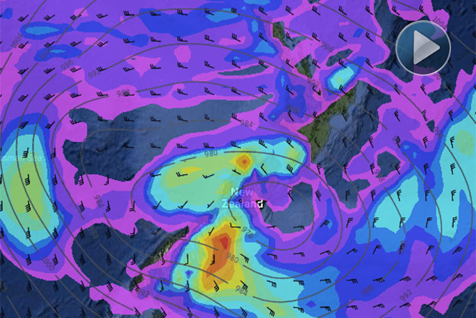
With the low so massive that it engulfs New Zealand it's easy to assume everyone's in for rough weather, says WeatherWatch.co.nz
'But larger lows often spread the energy further afield, so as the centre of the low crosses the South Island on Friday there will be a real variety of weather around the country with a showery mild north and a stormy wet south.
'Let's start with the centre of the low. The centre is where the winds are calmest. Across Friday this calm centre tracks across the upper South Island and towards North Canterbury and the Pacific Ocean.
'Rain is likely but the strongest winds are further out from the centre.”
Winds circle clockwise around the centre which means the North Island has nor'westers (mild) and the South Island south of this centre will have sou'easters (colder).
The bulk of the heaviest rain is in the southern half of the low - in other words, the South Island's east coast is most exposed to heavy rain that may cause slips and flooding.
'Mainly Otago, Canterbury and maybe Southland. These areas may get 150 to 200mm of rain around coastal hills, which may well cause slips, flooding and affect travel on highways/roads.
'In the North Island there will be heavy rain (mainly today and tonight) then by Friday there will be mild nor'westers and showers.
'This means the east of the North Island will be very different to the east of the South Island at the same time on Friday with the centre of the low separating them apart.
'The nor'west flow in the North Island means regions like Hawke's Bay and Gisborne may have a fairly sunny or dry Friday with highs up to 17 or 18 degrees, while patchy rain or showers affect the western North Island across the day.”
It's a big system and will take at least 72 hours to cross New Zealand.
As the centre of this low drifts further east on Friday and then Saturday we may see rain turning to heavy snow in the mountains of the South Island and therefore Alpine Passes. Rain in the east of the South Island and north of New Zealand looks to ease later on Saturday.
While rain in the Upper North Island on Saturday doesn't currently look severe, it may be heavy enough to cause localised slips and minor flooding due to so many areas reaching saturation point.

0 comments
Leave a Comment
You must be logged in to make a comment.