Regional civil defence manager Clinton Naude is advising people to check the Bay of Plenty civil defence website and Facebook page for updates on Cyclone Pam's approach.
'At this time it is best to take precautions, get prepared and keep up-to-date,” says Clinton.
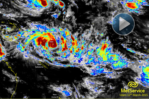
The MetService have stated that Tropical Cyclone Pam has the potential to cause severe weather in the northeast of the North Island. Photo: MetService.
'As soon as we get further information from MetService, we will put it up. We expect something later today to update and to get a more concrete idea as to what will happen.”
Civil defence only normally passes on warnings from MetService says Clinton, but with Pam they are making an exception.
Cyclone Pam is still growing in strength as she passes Vanuatu and New Caledonia and heads towards New Zealand, where the cyclone is expected to pass at an as yet undetermined distance east of East Cape.
'We will post updates to our facebook and our website,” says Clinton.
'We won't do so much in terms of full media releases unless there is something major changing. Also what we find is if we put too much out and not much is changing, people lose interest.”
BOP Civil defence is keeping in close contact with the duty forecasters at MetService. While warnings are yet to be issued, cyclone Pam is being treated as high priority.
At the moment there is still uncertainty about Pam's course. Tropical cyclones often downgrade to tropical lows by the time they pass New Zealand with wind speeds falling away as they leave the heat of the tropics.
The MetVUW model has Pam passing East Cape with hurricane strength-wind speeds near the eye of the storm.
'We do look at other sources, but the Metservice is the main source of information,” says Clinton.
'That's because we work closely with the Ministry of Civil Defence, which is responsible for the whole of New Zealand. So we link strongly with what the Ministry are doing and they rely strongly on MetService.
'For us at the moment, the biggest thing is the level of uncertainty. As we know in the past we have had a couple of cyclones that have impacted us and some that have gone past.
'As soon as MetService upgrades to a warning type level. we will put out more. We start monitoring straight off the bat, then we estimate the best time to start the messaging process.”
On Thursday afternoon, Tropical Cyclone Pam is a category four cyclone, expected to be upgraded to five on Friday morning, with winds near the eye rising to around 200km/h.
MetService Meteorologist Peter Little says: 'Tropical Cyclone Pam has the potential to cause severe weather in the northeast of the North Island, where heavy rain, severe southeast gales and large waves are likely from overnight Sunday through to early next week.”
For the latest Severe Weather Outlook, click here.

0 comments
Leave a Comment
You must be logged in to make a comment.