Flooding is causing chaos throughout the Bay of Plenty with sections of State Highway 2 closed at the Athenree and Karangahake Gorges and schools forced to close early.
A slip has closed the Athenree Gorge until further notice, while rising river levels have closed the Karangahake Gorge.
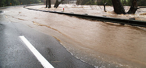
The Ohinemuri River rises to the level of the safety rail on SH2 at Waikino. Photo: Helen Wilson.
An alternative route to Waihi Beach past the Athenree slip is on Waihi beach Road onto Steele Road, then Athenree Road. Drivers taking this route are urged to use extreme caution as there is surface flooding.
Meanwhile Katikati College is asking parents to pick up pupils early because of concerns flooding will close bridges near the town.
A school spokesman says the major concern is that the Uretara bridge, north of Katikati, could be closed.
However constable Bernie Inglis from Katikati Police says all roads and bridges are still open in the area – including the Uretara bridge which is down to one-lane with surface flooding.
Another concern, the bridge by Claymark, near Sharp Rd south of Katikati, is still open with water 30cm below the bridge.
'It's difficult to say what it is going to happen – but with high tide at 10.30am this morning we are hoping it should start receding soon,” says Bernie.
Katikati parent Cherie Bryenton says it is 'bedlam” at the college.
North bound traffic from Tauranga is advised to use either SH29 via Tauranga or 25A, the Kopu-Hikuai road as alternative routes until the Karangahake Gorge flooding recedes.
The Tairua River at Hikuai on State highway 25 is also being monitored as levels rise, however high tide has passed and water levels are not expected to affect the road over the next few hours.
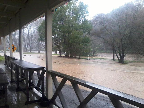
Waikino Tavern publican Naomi Greener says the surface flooding on the highway outside the tavern is from a creek just down the road by the Victoria Hall.
"It's not actually water from the river on the road," says Naomi.
"You can actually see some of the white lines on the road again now. It's a little bit freaky."
In the 1981 flood there was a metre of water in the bar.
"We have got an escape plan," says Naomi
The NZTA is monitoring all roads within the Coromandel area with heavy rain due to continue to fall in the area until tomorrow morning, says the NZTA's Acting Regional State Highway manager, Karen Boyt.
"We urge all drivers to continue to take extreme care in the region, drive to the conditions, and allow more time for their journeys so that they can reach their destinations safely."
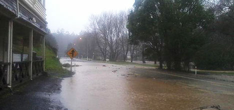
Flooding outside the Waikino Tavern in the Karangahake Gorge. Photo: Naomi Greener.
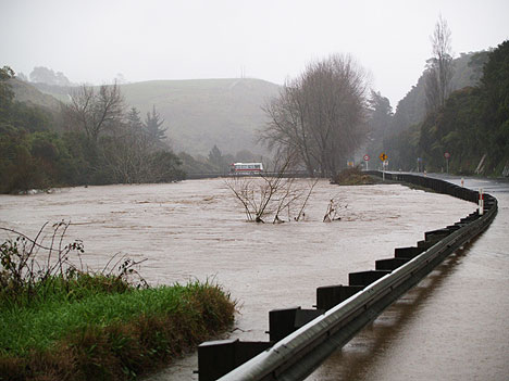
A school bus crossing the bridge near Owharoa Falls off SH2 at Waikino. Photo: Helen Wilson.
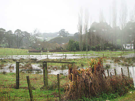
Flooding through the Karangahake Gorge.
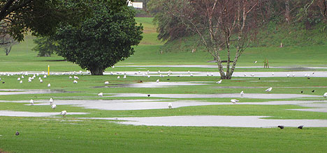
The Otumoetai Golf Course suffers flooding.
 An area of Redwood Lane in Tauriko.

5 comments
Flooded Highway
Posted on 23-07-2012 14:41 | By Brian61
This goes to show that we are in need of a tunnel to be created through the Kaimias for traffic to be able to get through without any hassles.
Access to Tauranga
Posted on 23-07-2012 16:26 | By tabatha
Since the building of new roads, housing etc the flooding into and out of Tauranga has got greater. Yes a tunnel would be ideal but what about the lovely scenery at the top of the Kaimais, you can see the Mountains in nNational Park on a clear day. We need to think like the people of Glenorchy and co in the South Island.But in reality a tunnel good but at this time we can ill afford. The Kaimais is great compared to the windy metal road it use to be and that was far better than the road north via Waihi.Perhaps the real answer is global warming, oops another can of worms opened up.
Flooding
Posted on 23-07-2012 17:28 | By kopchai
Hear hear Brian this shows that a tunnel is needed....Solve the problem...Could be a major if closed for days !
Reliable source
Posted on 23-07-2012 17:33 | By The author of this comment has been removed.
thanks so much Sunlive for keeping us updated all day. its a great service to the community. we have been able to plan our work around this excellent information. a big thumbs up to your news team. however a big thumbs down to whoever is responsible for the sign board on SH2 just south of Bethlehem, which still had all roads "open" at 4.30 this afternoon. The electronic board on clarks hill, a few miles north, had closures. c'mon, roading agency, pull finger and keep the board updated. if you don't know what's open and what's not, just check sunlive!
Sunlive Is Best
Posted on 24-07-2012 14:33 | By carpedeum
Fully endorse patsyann's comments- We find Sunlive TOPS ALL ROUND in all areas!!
Leave a Comment
You must be logged in to make a comment.