
The Bay of Plenty is saying goodbye to the weather system that saw wild weather lash the region yesterday – but it could be replaced by thunderstorms and hail later today.
The Kaimai Range was the worst hit area, with about 40mm of rain falling in the last 24 hours.
Localised thunderstorms and a chance of hail is predicted for this afternoon and this evening. Photo: File.
Whakatane and Tauranga saw around 20mm and in Galatea there was around 18mm.
'We are at the tail end of this system,” says MetService meteorologist Tom Adams, 'with some localised thunderstorms expected this afternoon.”
A trough is currently moving across the country, with a fairly significant low moving across the South Island.
But the worst of the weather associated with that actually came through yesterday, says Tom.
'The Bay has moved off the easterlies,” he explains, 'which tend to hit the Bay quite hard compared to the prevailing westerlies that New Zealand gets.
'That is a more favourable wind direction.
'As the low moves across the South Island, there are a series of troughs that spin around it which are going to be tracking across the North Island today.”
Looking at the radar, Tom says there is a good line of rain with some thunderstorms moving into the Waikato.
'There is a chance some of those thunderstorms will make it to the Bay of Plenty this afternoon through to tonight,” he adds.
'That could lead to some more heavy rain – about 10-25mm.
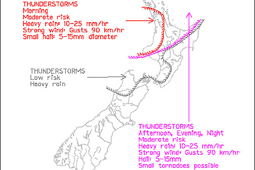
Photo: MetService.
'There could also be some wind gusts of up to 90km/h, and even a little bit of hail is possible.
'However, there is only a moderate risk of all of that happening in the Bay of Plenty.”
The last significant front is expected to cross tonight and things should improve tomorrow.
Rain will ease to a few showers tomorrow and the westerly winds are expected to die off.
'Things get a bit more interesting over the weekend,” adds Tom.
'There is a short ridge moving up the country. Just as this ridge comes across on Thursday and Friday, giving us a bit of a break, there is another low moving towards the upper North Island in time for the weekend.
'There is potential for some heavy rain and severe gales on Saturday, but that is a long way off and we only have a low confidence of that.”

0 comments
Leave a Comment
You must be logged in to make a comment.