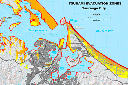
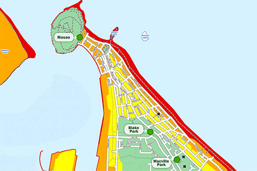
Maps of tsunami safe zones that can be reached in 40 minutes on foot from every part of the city and coastline are published today by Tauranga City Council.
The information is presented in new evacuation zone maps published on the council's and copies of the maps will be distributed to coastal properties next month.
Safe zone maps are available online and will be distributed to coastal residents next month.
A devastating tsunami could strike the Western Bay of Plenty coastline 40 minutes after a major earthquake along the Kermadec Trench, says city council emergency management manager Paul Baunton.
'That's not enough time for official warnings to be provided to the community,” adds Paul, 'so people need to treat a major earthquake as the best warning they may have and evacuate to a safe zone on foot as soon as they can.
And an important part of the message is walk, don't drive to the nearest safe zone.
'It's natural to think you'll be able to leap into the car and get away before everyone else,” he says.
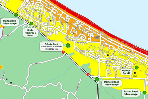
'But if everyone tries to drive out of Papamoa at the same time, it will take at least 6 hours to get everyone clear.
'That's on a good day with no emergency. That's why these maps are so important because they show us very clearly where people can walk to within 40 minutes to be safe.”
The time to run is if an earthquake knocks you over, or if the shaking goes on for more than a minute. Collect your pre-prepared emergency kit and walk to high ground or to the nearest safe zone.
'Fifty minutes is not enough time for emergency services to evacuate you,” he says.
'We encourage people to use these maps to plan and prepare ahead for themselves. Work together with your community. Plan with your neighbours, especially if you know they will need assistance getting to safety.”
The evacuation zone maps are a work in progress and will be updated online whenever new safe locations are established.
The Council is continuing to work with private landowners to establish additional tsunami safe locations. Three new tsunami bridges will be built in Papamoa in the first half of 2015.
'There are other safe locations we can build that require Council funding and planning over a number of years,” explains Paul.
'Those solutions are included in the proposed long-term plan. The main thing is that right now we have reliable information that people can use to plan their own tsunami evacuation with confidence.”
The new evacuation zone maps are available at: www.tauranga.govt.nz/tsunami
Key:
Red zone: Every tsunami will affect this part of the coastline. You should always evacuate this area if there is any sort of tsunami warning, whether that warning comes from unofficial sources, official warnings or natural warning signs.
Orange zone: In a formal Civil Defence evacuation you may be asked to move from the orange zone into the yellow zone. Tsunami from regional or distant sources (further away than 1000km) could take anywhere from 2-to-12 hours to arrive. You won't feel an earthquake for this type of tsunami so this is where warning systems, text alerts, emails, TV/radio and social media are important.
Yellow zone: The most devastating tsunami, similar to the one that hit Japan in 2011, is predicted to flood the yellow zone. There is a very low chance this will happen in our lifetime, but if it does there will be no time for official warnings. After a major earthquake it would take about 50 minutes for this tsunami to reach the coast, plus another 30 minutes to flood the yellow zone. The further into the yellow zone you get, the shallower and slower moving the water will be. If you plan ahead and evacuate as soon as you can after that first earthquake you have a very good chance of surviving.

5 comments
Infromation
Posted on 13-11-2014 11:13 | By Capt_Kaveman
40mins is not correct, Our risk lays between Fiji and New Caledonia (2,100kms)and afar 4hrs+, if council had designed Papamoa properly to start with escape would be much easier, and i advised them back in 1996 and nothing was done
This is good....
Posted on 13-11-2014 13:45 | By Jess66
....but why are there streets missing between the Mount and Papamoa maps on the official map site?
Cavey or mystic meg?
Posted on 13-11-2014 18:24 | By maildrop
I thought NZ had a fault line running top to bottom and an earthquake could strike at any time, anywhere, including just off our own coast. As far as I know even earthquake experts cannot predict where one will strike. Maybe you have forgotten Christchurch? Not sure why or how you have pinpointed Fiji / New Caledonia? Maybe you should offer your advice to leading earthquake experts seen as TCC ignored you. Can't imagine why.
Warning Time
Posted on 14-11-2014 09:21 | By The Caveman
If White Island goes "pop" in a BIG way there will be almost NO warning. Likewise if there is a major undersea quake in the Kermadec Trench, there will be very little warning.
maildrop
Posted on 14-11-2014 17:23 | By Capt_Kaveman
We are talking tsunami here if you cant keep on the subject dont bother coming here as yr insults only result on your limit of understanding, the shortest time tsunami risk if you want to know is East cape with the Kermadec fault is only just off the coast, this would hit the coast within mins not 40 prob less than 10, and ill say again the Kermadec Trench is not a great risk to the BOP,unless you understand how faults work your breath is empty
Leave a Comment
You must be logged in to make a comment.