A brand new set of tsunami evacuation signs in Mount Maunganui are being hailed as a ‘simple and easy' solution to helping point people in the right direction in case of a tsunami.
This morning members of the joint initiative between Tauranga City Council, Civil Defence and Tauranga Police unveiled 15 signs and information boards between Mauao and Banks Avenue west at the Mount.
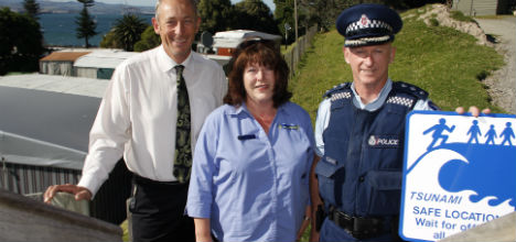
Tauranga City Council emergency management and safety manager Paul Baunton, Bay of Plenty Emergency Management group team leader Angela Reade and Tauranga Police Inspector Karl Wright-St Clair with one of the new tsunami evacuation signs. Photo: Tracy Hardy.
Council emergency management and safety manager Paul Baunton says using signs and information boards is easily the most universal way to communicate with people about what steps to take during a tsunami and where the safe zone is.
The signs are the first of a series that will eventually be installed along the city's coastlines.
'Once you have found the safest place for people to go you then you need to let them know how to get there.”
Information on the signs, predominately on Maunganui Road, Marine Parade and The Mall, points to Mauao as the nearest safe zone for everyone who is within walking distance of the mountain.
It's estimated the biggest tsunami threat to Tauranga City is one which would arrive 50 minutes after a major earthquake.
Paul says 30metres above sea level is predicted to be a safe level away from the tsunami, with Mauao the nearest high point within walking distance.
Paul adds residents beyond Banks Ave have not been forgotten with planning underway in the next three months for evacuation routes between Mauao and Papamoa and throughout the inner Tauranga Harbour.
'With tsunami evacuations it's either getting high or far away. For the people east of Banks Ave it's all about getting them far enough away from the tsunami.”
Bay of Plenty Emergency Management group team leader Angela Reade endorses council's initial work on getting the signs active and believes the timing of the signs is perfect for residents to familiarise themselves with the information.
She believes a push for the signs follows recent natural disasters in Japan and Asia which remain at the front of people's minds.
'Although tsunamis don't happen often it's the impact of it that worries people. So yes the public will be really happy to see progress in the Bay,” says Angela.
Tauranga Police Inspector Karl Wright-St Clair says the signs, internationally recognised, make it very clear about what people need to do and where they need to go.
'It's a very simple and easy plan and fits with the natural geography of the area.”
He says although council are the lead organisation on the project they both have the same goals which is to get people evacuating themselves – getting up the mount as quickly as possible on foot.
'Clearly know the routes and know where to go and be aware of your surroundings. Don't get into your vehicles and think you will be able to drive away from the area because that's just not going to happen," says Karl.
The remainder of the evacuation route planning is expected to be finished within six months to a year with more time needed for evacuation signs and infrastructure to be rolled out across the city.
More information about the evacuation route planning can be found at www.tauranga.govt.nz.

6 comments
Are humans this stupid???
Posted on 18-12-2013 15:48 | By Sambo Returns
that we require to be told too head to high ground if a "tsunami" is approaching, common sense and survival instincts should prevail, this is something for "dumb and dumber" the 2 brothers who when asked to stand in the corner of a round room, asked which one.
Treating us as stupid?
Posted on 18-12-2013 17:06 | By Phailed1
The photo and sign seem to be at the base of the Mount. Are there enough brainless people to need signs to point to high ground? And just who is making a "push" for signage? I thought the clearly stated push was for sirens, even though they aren't the complete answer.
Is this for real.......
Posted on 19-12-2013 11:34 | By FunandGames
Your standing at the bottom of a big hill and you need to be told what and where to go for safety in a Tsunnami???
Signs
Posted on 19-12-2013 12:18 | By YOGI BEAR
Like they say ---->>>> way to the hills? Like have we figured that already ... the challenge is to know if there has been a earthquake causing a Tsunami, now there is the challenge.
Visitors
Posted on 23-12-2013 18:53 | By Papamoaner
Comments seem to be unanimously against these signs, but to be fair I think they are for visitors as well as locals, and not all visitors will know the way to the mount. I am more concerned about the ineptness of apparently deeming 50 minutes insufficient time to trigger sirens. That in itself is a symptom of extreme beaurecracy. Keep it simple guys. When the tsunami is imminent there will be people swimming who need to hear a siren so they know to look to the beach for signals, and that is only one small group in the community that telecommunications warnings will not work for.
The Cart Before The Horse
Posted on 28-12-2013 15:59 | By Jitter
It's great that BOP residents will know where to go in the event of a tsunami. However if they don't know one is imminent what is the point of the signs ? Surely an audible warning is a must to tie in with the signs and should be activated as soon a major seismic event occurs somewhere in or around the Pacific that is likely to effect NZ ?
Leave a Comment
You must be logged in to make a comment.