Cyclone Cook remains a Category 1 cyclone although it should become an ex-cyclone by Thursday.
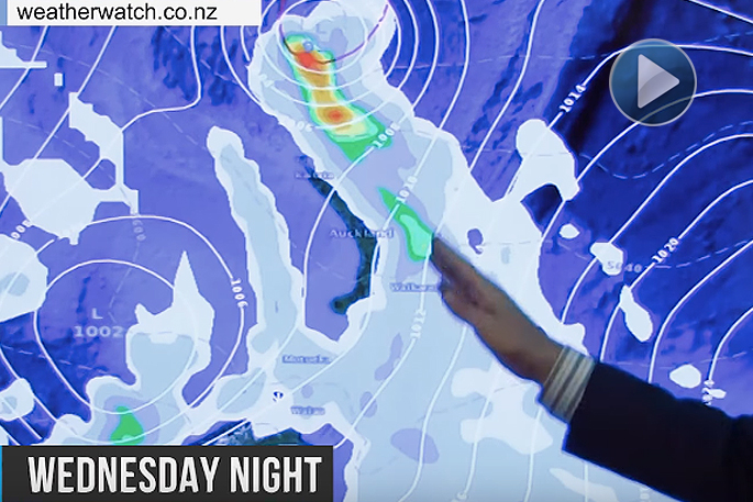
The latest update from WeatherWatch.co.nz says the latest tracking on Thursday is more concerning for New Zealand with Cook likely to make landfall in the afternoon or evening around western Bay of Plenty.
It's then predicted to track southwards through the North Island and down the South Island's east coast.
'Major cities like Auckland, Hamilton, Tauranga, Wellington, Christchurch and Dunedin may all have a burst of severe weather from not only Cook but also the Tasman Sea low it is now merging with around New Zealand,” says the weather organisation.
'We take a look at the latest tracking and forecasts as we head into Wednesday PM and Thursday.”
*Please note, this was recorded around noon on Wednesday we're already seeing very heavy downpours moving into the Auckland region and eastern Northland. Tropical-like downpours are highly likely pretty much anywhere in the Upper North Island over the next 36 hours.
Stay safe on the roads during severe weather event
With many areas across New Zealand expected to hit by severe weather over the next couple of days, the NZ Transport Agency is reminding all road users to take extra care.
Transport Agency contractors have prepared for the severe weather event by checking all flood prone areas and ensuring the availability of extra staff.
Transport Agency Highways Manager, Niclas Johansson, says road users should plan ahead, check weather and road conditions before they travel.
'Simple guidelines for travelling in wet weather include ensuring your vehicle is safe, always driving to the road and weather conditions, allowing more time for your travel, slowing down, being prepared for unexpected hazards and allowing greater following distance between you and the vehicle ahead.
'The room for mistakes is reduced when road and weather conditions are less favourable, and we don't want anyone's mistake to end in an avoidable tragedy.
'Most important though is to plan your journey, check weather and road conditions, choose the safest route if you have the option and if possible avoid travelling in extreme weather and road conditions.
'With the weather that is predicted, including heavy rainfall and strong winds, be prepared for challenging driving conditions, possible road closures and detours. Road closures and restrictions are put in place for your protection and other road users, so please observe these,” Mr Johansson says.
If you plan to travel to popular spots such as the Bay of Plenty or Coromandel over Easter make sure that you have sufficient food, water and medical supplies and be prepared for slips on the road and delays as we work to clear them.
Current weather related road updates:
The Transport Agency currently has no new weather related closures in the Waikato and Bay of Plenty since Cyclone Debbie passed last week.
This table shows current closures and lane closures – use www.nzta.govt.nz/traffic for the latest updates.
Check the latest weather conditions here: http://www.metservice.com/national/home
|
SH |
Location |
Road Status |
|
SH2 |
Waimana Gorge (Bay Of Plenty) |
Closed |
|
SH2 |
Awakeri to Taneatua (Bay of Plenty) |
Closed |
|
SH2 |
Edgecumbe (Bay of Plenty) |
Closed |
|
SH30 |
Rotorua to Whakatane (Bay Of Plenty) |
Lane Closed |
|
SH2 |
Waioeka Gorge (Bay Of Plenty) |
Lane Closed |
|
SH25 |
Ruamahunga (Waikato – Coromandel) |
Lane closed |
|
SH34 |
Edgecumbe to Te Teko (Bay Of Plenty) |
Open |
Motorists can get real time information from:
• 0800 4 HIGHWAYS (0800 44 44 49)
For Waikato/Bay of Plenty updates:

0 comments
Leave a Comment
You must be logged in to make a comment.