The good weather is about to take a stormy turn with the MetService warning a 'weather tantrum” will end the school holidays.
Heavy rain and gales are forecast for the Saturday, with the meteorological service expecting weather warnings to be issued on Friday morning.
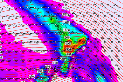
Sunday morning's outlook from Metvuw. Image: MetVUW
'The weekend weather will lead to dangerous conditions on the roads”, says meteorologist Tom Adams. 'And motorists heading home from holidays are strongly urged to check the forecasts and plan ahead – even if that means coming back earlier or later than planned.”
The weekend is expected to bring stronger gusts to many regions – stronger than the winds that uprooted trees and toppled chimneys in the Waikato on Tuesday night.
Most of the North Island is at risk of strong northwesterlies Saturday night, and upper South Island earlier in the day, with the possibility of gusts reaching up to 120kph in exposed places, and possibly as much as 150kph about the Wellington hills.
The strongest winds will hit the Kapiti Coast Saturday night around high tide, increasing the chance of inundation on coastal roads.
Heavy rain is also expected, especially in the west and in the ranges, with warning rainfall amounts of 100mm in 24 hours likely to be met in the western South Island and the Canterbury and Otago headwaters on Saturday.
The cause of the wild weather is a very strong northwest flow over the country between a departing high northeast of the country and a deep low over the Southern Ocean. This northwest flow brings warm topical air across the Tasman resulting in warm temperatures, heavy rain and strong winds.
Behind this front, colder air surges up from the south crossing the South Island on Saturday and reaching Wellington in the early hours of Sunday.
This colder air is expected to bring another dusting of snow to the southern ski fields which is welcome news, but may also affect some higher roads and alpine passes.

0 comments
Leave a Comment
You must be logged in to make a comment.