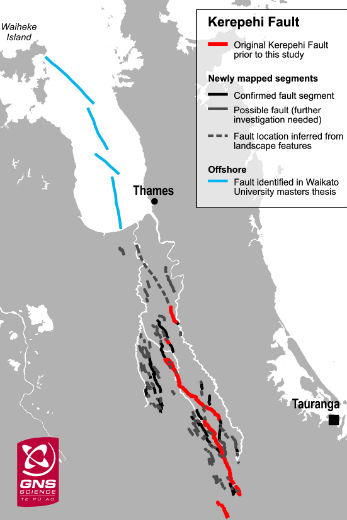
New research has revealed a fault line in the Thames area is more complex than first thought geologists say.
The Kerepehi fault, which runs for about 80km between Matamata and north into the Firth of Thames, has revealed the fault is more complex than previously thought.
New research shows startling results. Photo: File.
Prior to this research the fault was thought to consist of up to five loosely connected single strands or segments.
The new research has shown it consists of a belt of many faults, in a wider zone suggesting a more complicated arrangement of segments.
The research took place over several field seasons and involved topographic mapping and excavations across many of the major onshore strands of the fault.
Prior to the research, scientists understood the average interval between ruptures of the Kerepehi Fault was between 6000 and 8000 years, based on the better studied segments. Although there is one period several thousand years ago when three quakes appear to have clustered relatively closely in time.
However, the new research combined the rupture history of all fault segments studied so far, and found the average rupture interval to be about 1000 years.
In other words, the rupture interval on a single segment of the fault is still likely to be several thousand years, but the region may experience a large earthquake every 1000 years.
The research was undertaken by a team from GNS Science led by geologist Dr Pilar Villamor and post-doctoral collaborator, Dr Mira Persaud, who had funding from the Swiss National Science Foundation.
The investigations revealed a pre-historic record of larger earthquakes than those which have occurred in the past 1000 years.
The ruptures have involved up to 2m of vertical displacement of the ground surface per event, which suggests associated earthquakes were between magnitude 6.3 and 7.0.
Dr Villamor says earthquakes of this size will result in significant damage to weaker buildings, disrupt services, threaten flood defence structures, and cause liquefaction in weak soils where the water table is close to the ground surface.
Results of this investigation have been discussed with both Waikato Regional Council and Hauraki District Council. Hauraki District Council has proactively engaged with the local business and civil defence community in a November 2015, workshop to consider how the new understanding of earthquake hazard in the district can be managed.
While the new research has added considerably to the knowledge of the Kerepehi Fault, there are several strands of the fault having received little scientific attention.
Dr Villamor says further work is needed to estimate the impacts of a major earthquake in the region to assess options for strengthening local infrastructure and to evaluate business resilience.
The Hauraki Plains is a region of moderate recent earthquake activity with significant earthquakes in 1920, (near Te Aroha), 1926 (Morrinsville), and 1972 (Te Aroha). The 1972 magnitude 5.1 quake was centred 4km south of Te Aroha and 1km east of Waihou, and resulted in 1300 claims to the Earthquake Commission for property damage.

0 comments
Leave a Comment
You must be logged in to make a comment.