Severe weather warnings for strong winds, heavy rain and thunderstorms remain in place as a storm bears down on the region.
According to tepukeweather.co.nz, 0.9mm of rain has fallen in the region.
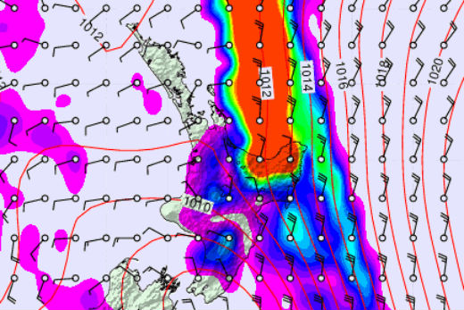
Strong winds and heavy rain is forecast for the day. This image shows the heavy rain band as predicted at 7pm. Image: Metvuw.
However, more rain is predicted for the region as a trough, which is preceded by a strong moist northeasterly flow, brings significant rain to northern and western parts of both islands.
'Periods of heavy rain were forecast to affect Northland, Taranaki, the Coromandel Peninsula, Marlborough, Nelson, Buller and Westland overnight, and about Bay of Plenty, Rotorua and Gisborne from Thursday until Friday morning,” says a statement from the MetService.
'The strongest winds are expected to affect the north and west of the North Island with severe gale northeasterlies gusting 120 km/h, especially about Northland, Auckland, Waikato, Taranaki, Whanganui, Taihape and northern Manawatu until Thursday morning. Severe northerly gales are expected to affect Wellington this morning.”
Severe weather has already seen about 200 people evacuated in the small South Island tourist town of Franz Josef.
The Waiho river, near Franz Josef, breached its bank 50m north of State Highway 6 at 11.50pm on Wednesday as heavy rain fell.
A local state of emergency was declared at 2am.
Further north, thousands of people are without power across the Auckland and Northland regions.

1 comment
Rain
Posted on 24-03-2016 13:41 | By Flacon
Just a note, there was an issue with the rain meter at Te Puke Weather this morning, it has not been replaced :)
Leave a Comment
You must be logged in to make a comment.