Cyclone Winston isn't yet being described as an old blowhard gasping its last as it comes ashore in New Zealand.
This indecisive storm idoesn't know whether to swing left or right, and is hanging around Northland, says Weatherwatch.co.nz meteorologist Phil Duncan.
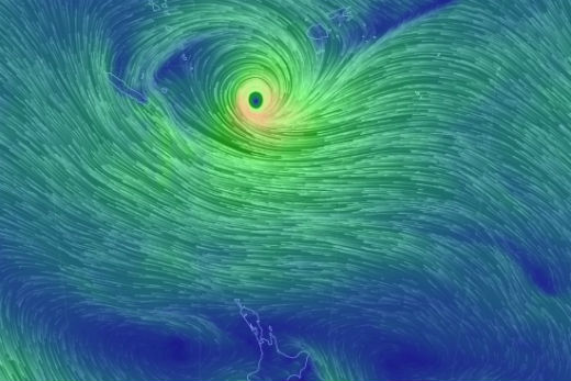
Winston is messing with forecaster's predictions.
'There will be a touch of relief when the system's gone. Especially when everyone's so political.”
Cyclone Winston is defying the experts and the computer modelling predictions.
'It would probably be the most bizarre cyclones I've ever tracked, and I've tracked a lot of tropical storms in my time. It's because of the high over New Zealand, and it's the high that keeps changing shape and pushing the cyclone around - a bit like a pin ball in a pin ball machine.
'I've seen tropical cyclones go round in circles before, there's nothing new in that. There's certainly nothing new in a cyclone back tracking where it came, that's very normal,” says Phil.
'But it's unusual to see a cyclone that's moving around like this one. The computer models just have absolutely no clue what's happening 72 hours from any given point, and that's been the weirdest thing. The modelling's normally really accurate, plus or minus 500km or so. But this one's a tough one. It's really challenging everyone.”
At present cyclone Winston is heading towards the North Tasman Sea and it's going to be a very close call for Norfolk Island tomorrow night.
But once it gets to Sunday, forecasts are unsure. Until Saturday all the models are in general agreement – Winston will be in the north Tasman Sea heading towards Australia to some degree.
The confusion is whether Winston will keep on tracking towards Australia, or turn round and head towards New Zealand.
The American model is saying Winston will head down the Tasman Sea and hop across the central North Island early next week. The European model is saying no, it's going to go to Australia.
'But two days ago they were both saying the opposite,” says Phil. 'So there's definitely something out that that's making them think that, there's obviously some data that's strong enough to say the high over New Zealand might strengthen and push back, and do what it did a week and a half ago and push Winston back up into the tropics.
'I would say there's a 40 per cent chance of that happening, which leaves us with a 60 per cent confidence that we will get the low coming over the north island.”
Rain is the main concern. By the time Winston reaches New Zealand it will be down-graded from a tropical cyclone to a sub-tropical low with a lot of rain and humidity attached to it, says Phil.
'It has the potential to create some very heavy rain and dangerous beach conditions. Those are the two main concerns,” says Phil.
'By Friday we will know whether the storm is coming out way, or if it's been delayed because the modelling yesterday was pretty much in agreement that Sunday to Wednesday there was a good chance of this low coming in.
'Now half of that modelling says ‘no' that's not going to happen at all. And so we just have to wait another two more days before we can figure out what's going on.
'It is a confusing cyclone that's for sure.”

3 comments
I
Posted on 24-02-2016 21:46 | By Capt_Kaveman
predicted the other one to stay off N Queensland and it did, im gonna take a shot here and say this will move SW then IF it drops below 30south it will accelerate S then SE across the north island
finnnaly
Posted on 25-02-2016 00:37 | By jjrk
finaly some realist forecasts.... you cannot predict these things.. it sure beats how not to long ago we were made to be concerned about forecasts one week ahead... i am thankful now the media is encouraging us to take take a more observant role and less of an over sensationlist one
clear evidence
Posted on 25-02-2016 12:18 | By kurgan
of weather manipulation via chemtrails and EMF beams
Leave a Comment
You must be logged in to make a comment.