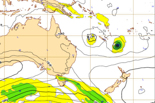
Two tropical lows developing north of New Zealand are threatening wind and rain next week.
A tropical cyclone forming between Fiji and Vanuatu today is expected to track towards New Zealand over the next few days.
Cyclones are developing north of New Zealand. Picture: Weatherwatch/ECMWF
Swells and waves around Monday and Tuesday look rough, with 3 and 4 metre waves coming into eastern coastlines of the Upper North Island – areas such as Northland, Coromandel Peninsula, Bay of Plenty, Gisborne and Hawke's Bay are expected to see big swells.
A second low is also developing in the Coral Sea south of New Caledonia. This second tropical low pressure system may end up dragging rain and humid easterlies onto New Zealand, but an earlier scenario – that the two lows would combine and slam dunk the country, is now looking less likely.
The second low is bringing some heavy rain risks to the country.
Today's expectation is the first low will bring dangerous beach conditions similar to Cyclone Victor's pass last week – and the second one bringing tropical humid rains to the north.
'There are pretty dangerous sea conditions on Monday and Tuesday coming in,” says Philip Duncan, meteorologist at Weatherwatch.co.nz.
'Our advice is to stay out of the water, just like with cyclone Victor, if it's something you don't think you can handle.
'Surfers will go out regardless but the average beach goer should be aware this could be quite a dangerous couple of days.”
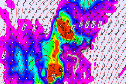
Next Wednesday's weather according to Metvuw. Image: James McGregor.
The cause is a developing cyclone between New Zealand and Fiji.
'It's probably going to develop into a cyclone today, and has the chance to become a severe cyclone over the weekend.
'While it's in that fairly big intense state out at sea, that's what will generate these big swells and waves that will come into the Bay of Plenty on Monday.
'So even though the storm's not coming to us, by the looks of it, the swells will. That's the second part of these storms is the dangerous beach side of it.”
The good news is the Fiji low doesn't look like it is going to bring severe weather to the land.
'But cyclones have a mind of their own, sometimes the maps look like nothing in the real world,” says Philip.
The weather maps are produced by computer models that arrange available data into forecasts.
There are two sources the US Government and the Europeans and the two sources don't agree.
One says the cyclone will hit New Zealand the other says it won't. The middle ground is probably reality.
The cyclone will probably won't hit New Zealand but the country will be affected by the swells.
By mid-morning Friday there will be a better view of which model is the more accurate one, this time.
'Regardless of these two cyclones there's a really big pool of low pressure just north of New Zealand at the moment so we are sort of dancing on a fine line between summer weather and tropical downpours,” says Philip.

1 comment
2 cents worth
Posted on 11-02-2016 17:49 | By Capt_Kaveman
the western low Cyclone Twelve New Caledonia look out, Cyclone Eleven - more swells
Leave a Comment
You must be logged in to make a comment.