.jpg)
MetService is reporting that the North Island/Te Ika-a-Māui had the "chilliest temperatures" overnight on Saturday, especially about the Central Plateau.
The temperature at Taupo Airport dropped to -1.5 degrees Celsius, Raetihi was -1.8, Galatea -2.2, Desert Road -3.4, and south Waiouru was the lowest at -4.0 degrees Celsius.
It turns out that the date April 28 has been noteworthy over the last 100 years for weather-related events occurring on this day in New Zealand.
.jpg) Temperatures across the Central Plateau on Saturday night, April 27, 2024. Background image: Primo's webcam over Tarata in Taranaki.
Temperatures across the Central Plateau on Saturday night, April 27, 2024. Background image: Primo's webcam over Tarata in Taranaki.
The MetService have posted some interesting facts from this day in history on their Facebook page.
“Looking through the records, the 28th of April often seems to be quite eventful weather-wise, but not this year,” says MetService's Clare O'Connor.
In 1932, two yachts and a launch were pounded to pieces in a fierce easterly gale which struck Auckland during the morning. A number of other boats were blown ashore and were damaged.
“A visit to the waterfront showed the gale in its ugliest mood. An unusually muddy looking harbour was white with broken water.”
In 1990, a New Plymouth hotel suffered damage when it was hit by lightning. The lightning blew out the hotel’s telephone system, fire alarm, tills, computers, televisions, videos, antenna system and refrigerators.
In 2002 on this day, the occupants of a house on the southwestern shore of Lake Taupo escaped uninjured after a lightning strike badly damaged their house. The lightning started a small fire and blew out a wall in the house.
In 2006, a Whakatane primary school was shut down after a bolt of lightning struck an outside light attached to a classroom. A 10-year-old student described the bolt of lightning as a shotgun going off in his ear. The school lost power to a large portion of its buildings.
On this day in 2014, more than 300 homes in Timaru lost power due to strong winds damaging power lines. Strong winds brought down a large tree west of Wanaka, completely blocking Mt Aspiring Road.
Finally, in 2015, a heavy downpour of rain in the early hours caused considerable surface flooding in central parts of Wellington. Between 4am and 5am, 18mm of rain was recorded at Kelburn.
Cold start on Saturday
Saturday morning was also a cold start for many, with most of New Zealand recording less than 10 degrees Celsius at around 7am.
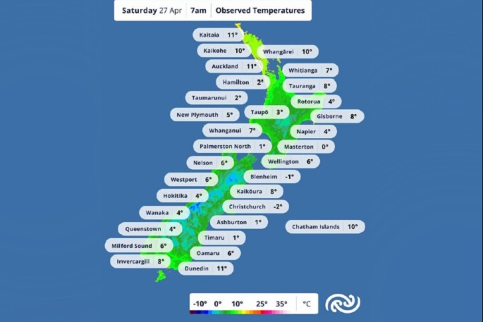 New Zealand temperatures recorded at 7am on Saturday April 27. Image: MetService.
Clare says that Christchurch/Ōtautahi dipped to -2.9 degrees Celsius at 6.09am, on Saturday morning.
“[This is] not only the coldest morning recorded at Christchurch Airport in 2024 (so far!) but the third coldest April temperature we have recorded there since 1954!” says Clare.
Over the other side of the city, New Brighton Pier was 4.5 degrees Celsius on Saturday morning.
“On this day [April 27] in weather history, in 1870: Snow blanketed the streets of Christchurch during a particularly cold southerly outbreak,” says Clare.
Clear night skies perfect for star gazing
It turns out that cold overnight temperatures are often an indicator of a clear night skies, says the MetService.
“As we move into the waning moon phases, the evening sky darkens quickly after sunset,” says Clare.
“In the west, Orion - or The Pot - sits low in the sky, with the bright stars of Rigel/Puanga and Betelgeuse/Pūtara putting on a show as they twinkle above the horizon."
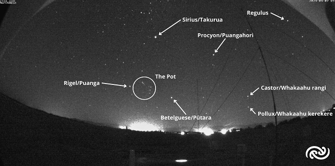 Western sky. Image: MetService.
“Slightly higher in the sky and hard to miss is Sirius/Takurua - turning towards the south and looking slightly higher again is Canopus/Aotahi," says Clare.
“These two stars are the brightest that you can see in the night sky. As they set around 11pm, these stars will begin to sparkle due to the distortion of the atmosphere.
“Three zodiac constellations are visible in the bottom image: Gemini, Cancer, and Leo. Cancer is between Gemini and Taurus, but the legend goes that the crab ate all the bright stars of the constellation; hence there's not a lot to see!”
"The Bay of Plenty will cloud over overnight but early in the evening tonight is your best chance to spot those stars; although they will be visible after sunset for another couple of weeks yet," says Clare.
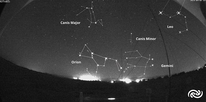 Night sky constellation. Image: MetService.
For those wanting to learn more about star constellations, check out your local astronomical society. RASNZ has a directory here: www.rasnz.org.nz/affiliated-societies/general-information.
The Tauranga Astronomical Society, which meets at their observatory in Fergusson Park, Tauranga, is due to hold their next meeting on May 14. This will coincide with the Moon being at an ideal phase for viewing the craters, through the society's telescopes, weather permitting.
With all this wonderful 'geeking out' around weather history facts and exploring the stars, the question is, says Clare at MetService, do you want a cold morning but sunny day, or a cold snow day?
The weather ahead
On Tuesday, April 30, a front, preceded by a strong moist northwesterly flow, is expected to move northeast over the lower South Island.
There is moderate confidence that rainfall accumulations will meet warning criteria in Fiordland, and low confidence for Westland District. There is also low confidence that northwest gales will become severe for a time in Fiordland, Southland and Otago.
On Wednesday, the front weakens as it moves northwards, followed by a cool southwesterly flow. There is low confidence of significant heavy rain over Westland district.
Cold and showery southwesterlies are expected to affect many areas on Thursday, however, severe weather is unlikely.
At the end of the week on Friday, May 3. the cool southwesterly flow is expected to ease, with severe weather again unlikely.

0 comments
Leave a Comment
You must be logged in to make a comment.