A chance of thunderstorms is being predicting for the Bay of Plenty today as temperatures cool leading to increasing instability.
The Metservice reports daytime heating is becoming strong enough to trigger afternoon convection along lines of wind convergence.
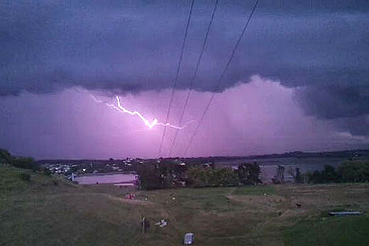
Lightning from Matapihi back in January. Photo: Andrew Jenkins.
 The MetService is warning of a chance of thunderstorms in the Bay of Plenty this evening.
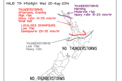
'This morning, there was a moderate risk of one or two thunderstorms over northeastern Northland where a narrow band of heavy showers is moving southeast,” says a statement from the weather forecaster.
'There is now a high risk of scattered thunderstorms forming over Northland, Auckland, Waikato and Coromandel Peninsula this afternoon with rainfall rates generally in the 10-25mm per hour.”
There is an additional risk that one or two of these may produce localised downpours in the 25-35mm per hour, due to heavy showers moving over the same location for several hours, MetService reports.
'All this activity is expected to move out of Northland towards evening and then move from Auckland, Waikato and Coromandel Peninsula into Bay of Plenty this evening.”
Once the front reaches the Bay, there is a chance of rain reaching 10-25mm per hour, with small hail likely to form.
'For all other locations north of a line from north Taranaki to East Cape there is a low risk of thunderstorms through the period. Elsewhere, no thunderstorms or significant convection expected.”

2 comments
Cool
Posted on 20-08-2014 17:18 | By Capt_Kaveman
Goodie Goodie Goodie nothing like a good thunder storm just to let humans know that nature is King :-)
@Capt_Kaveman
Posted on 20-08-2014 17:54 | By Sambo Returns
is that why its called human nature?, well I will be damned.
Leave a Comment
You must be logged in to make a comment.