While the severe weather warning for BOP lifted, a thunderstorm watch remains in place with unsettled weather forecast to continue.
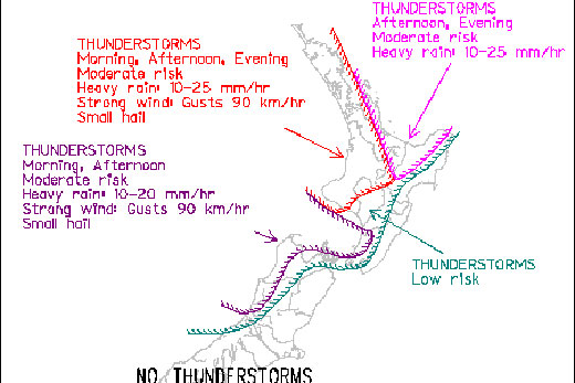
According to MetService, there is a main threat of thunderstorms with a cold front crossing North Island today, but continued risk of isolated storms for central New Zealand and western North Island until this evening.
Photo: MetService.
A cold front moving onto western areas of the North Island this morning will continue eastwards across the island today, crossing Auckland around midday and Bay of Plenty this afternoon and evening.
A few thunderstorms have already been observed in this frontal band near Taranaki and over the Tasman Sea, and there is a moderate risk of further stormsaccompanying the front as it crosses western and northern parts of the North Island today.
Any thunderstorms with the front are expected to bring brief heavy rain, strong wind gusts and small hail.
Behind the front, MetService says an upper level cold pool will cross central NZ this afternoon and evening, supporting a broad area of showers, with bands of heavy showers and isolated thunderstorms.
A few thunderstorms have already spread onto Buller and northern Westland, and there is a moderate risk of these isolated thunderstorms spreading to northwest
Nelson and the Sounds this morning, then onto western areas of the North Island from northern Wellington up to about Waikato this afternoon or evening. These storms may also bring brief heavy rain, strong wind gusts and small hail.
There is a lower risk of one or two thunderstorms spreading a little further east as indicated on the chart, with no thunderstorms expected in the east and south of the country today.
MetService is forecasting afternoon showers with possible thunder for Tauranga today, with a high of 21 degrees and an overnight low of 13 degrees.
The storms of the past few days have caused some issues around the Bay of Plenty, with worst hit areas appearing to be around Whakatane and Eastern BOP.
Bay of Plenty Regional Council warns river levels are high around the region with ‘first warning' levels issued on Friday night since dropping away.
A number of areas in Whakatane, Ohope and Coastlands have experienced surface flooding, power outages, and other issues. Several roads closed due to flooding, slips and other hazards, with Whakatane Emergency Operations Centre activated Friday evening.
Some properties have been evacuated in the Alexander Ave/Douglas St area.
The Whakatanene River at Valley Rd has passed the first warning level and boats are being removed from their moorings on the river.
The Okere Gates are at their maximum setting and the Rotoiti lake level is falling slightly. The Gates are likely to remain open the rest of the weekend but will be reviewed regularly.
There are many power outages at pump stations for drainage schemes and power companies are working to restore power and regional council staff is also attending to pumps.
Find out more about current river levels and other information on regional council's live monitoring site.
BOP Regional Council and other local national and local authorities will continue to closely monitor the situation and provide regular updates as the situation changes.

0 comments
Leave a Comment
You must be logged in to make a comment.