An active cold front surges through Wellington this evening, sweeping gale force southerlies over southern and eastern North Island areas in its wake.
Cold Antarctic air behind the front lowers temperatures considerably around the country, with snow gradually falling to 400 metres in Southland and Otago this afternoon and evening, to 300 metres in Canterbury and to 500 metres in Marlborough.
Severe Weather Watches and Warnings associated with this system are in force for many parts of the country, and people travelling should check the NZ Transport Agency website for any road closures before heading out. Conditions improve over the South Island during Friday, as a ridge of high pressure moves in from the Tasman Sea.
The cold blast moves north over eastern and southern parts of the North Island through Friday, with heavy rain, and snow down to 700 metres during the day, further lowering to 500 metres in the evening and the rain easing to a few showers.
MetService has issued road snowfall earnings for several South and North Island roads. Clearing skies and winds dying out over much of the South Island on Friday are a good recipe for frosts to form Friday and Saturday nights.
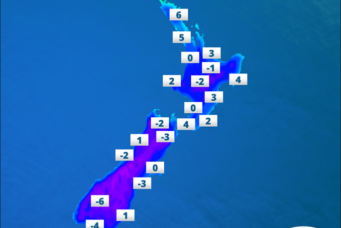
'Mosgiel people will wake up to -3C Saturday morning, and to -4C Sunday morning, while people in Middlemarch see a severe frost of around -10C both Saturday and Sunday mornings,” says MetService Meteorologist Andy Best.
'Other places such as Lincoln in Christchurch sees -2C Sunday morning, Queenstown -6C.”

1 comment
Nice headline
Posted on 27-07-2017 18:24 | By Papamoaner
I guess it depends on what they're having for dinner at Scott Base.
Leave a Comment
You must be logged in to make a comment.