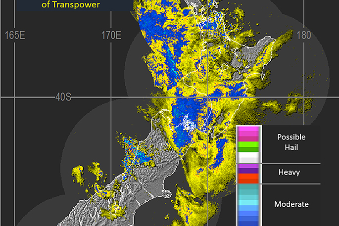
UPDATED: The MetService is forecasting 150 to 200mm of rain for parts of the Bay of Plenty and Gisborne ranges as a slow-moving front moves over New Zealand.
Lower lying parts of Bay of Plenty and across the central North Island High Country to the headwaters of the Whanganui River may receive 100 to 140mm of rain, the weather organisation says in its latest weather warning update.
'Localised downpours with intensities of 25 to 40mm per hour are likely in these areas, and other North Island areas as detailed in the severe weather watch.
'This amount of rain will cause rivers and streams to rise rapidly, and may cause surface flooding and slips. Driving conditions will also be hazardous.”
Meanwhile, as the remnants of Cyclone Donna drift southwards and out of the tropics, they are expected to move into a more favourable environment and the low is expected to deepen.
There remains some uncetainty, but this low may pass near to the east of the North Island during Friday or early Saturday as it tracks southwards.
'As a result, further heavy and strong winds may affect parts of northern New Zealand.
'MetService Meteorolgists are monitoring this situation closely in case additional Severe Weather Warnings or Watches are required. Please keep up to date with forecasts.”
EARLIER:
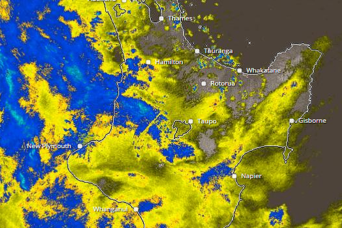
A severe weather warning remains in place for the Bay of Plenty this morning as more rain is possible for the region.
MetService issued the warning yesterday saying a slow-moving front was making its way over the northwest of the South Island overnight, and moving onto the North Island this morning.
The front is then expected to move east of New Zealand on Friday.
'A period of northerly rain is expected over much of central and northern New Zealand ahead of the front,” says the weather organisation.
'A further 100 to 140mm is possible about the ranges of Nelson through to Thursday afternoon. Further north, Mount Taranaki and parts of Bay of Plenty and the ranges of Gisborne may receive 160mm of rain in a 12 to 21 hour period.
'This amount of rain will cause rivers and streams to rise rapidly, and may cause surface flooding and slips.”
The warning is expected to be reviewed at 9am. SunLive will then bring you the latest update.
WeatherWatch.co.nz says a frontal system moves from west to east over the South Island this morning then the North Island later in the day/overnight.
Ex TC Donna positions itself just north of the North Island overnight, says the weather organisation.
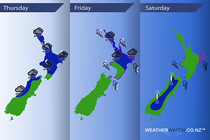
A southerly airflow spreads over much of the country on Friday while ex TC Donna moves southeast just of the northeastern side of the North Island during the day, a high pushes in on Saturday while ex TC Donna moves away to the east.
Thursday
Blue - Rain about the West Coast of the South Island and Nelson / western Marlborough is heavy this morning then easing to showers, showers may continue to be heavy at times till evening with the risk of a thunderstorm.
Rain possibly heavy about northern Taranaki during the day, from late afternoon or evening rain becomes heavy about the western North Island then pushing over much of the North Island overnight where rain could become torrential in some regions.
Purple - Gusty north to northeasterly winds about coastal Taranaki and perhaps parts of the outer Marlborough Sounds / through Cook Strait then easing late afternoon or evening.
Friday
Blue - Heavy rain about northeastern parts of the North Island eases from afternoon, heavy / torrential falls about East Cape and Gisborne may not ease till overnight.
Purple - South to southeasterly winds strengthen during the day through Cook Strait and many North Island coastal areas, winds may gust to gale especially about Gisborne, East Cape and the Coromandel from evening.
Saturday
Blue - A cold start about the inner South Island reaching down to 0 to -2 degrees celsius. -3 to -4 isn't out of the question for some parts of inland Otago and inland South Canterbury.
Purple - Strong south to southeasterly winds ease over the North Island during the day, the strongest winds will be about coastal Gisborne / East Cape with gales likely. Strong southerlies may remain about coastal Gisborne / East Cape through the night and then finally easing on Sunday.

0 comments
Leave a Comment
You must be logged in to make a comment.