Reliable computer models are fine tuning their forecasts and the latest on where Cook may make landfall shifts it closer to Auckland and Coromandel Peninsula and sends even more rain over flood hit Bay of Plenty.
Both European and American models are this morning (and were last night) placing the centre of Cook (which will be an ex-cyclone when it makes landfall in New Zealand late Thursday) somewhere around Tauranga or even the Coromandel Peninsula, says WeatherWatch.co.nz
'Yesterday the centre was likely to make landfall in Whakatane or even further east towards Gisborne. This is still possible also.
'This is about an 80 to 250km difference and is very normal when a tropical storm approaches any country. This shows that as the models fine tune where Cook will make landfall precisely it may still shift a bit, although the distance it may shift usually reduces as we get closer to the time.
'This last firming up of the models places far more people at risk of severe weather over the following two days.
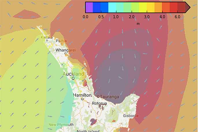
'It's very important to note the severe weather around the centre of Cook extends for about 150kms to 200kms roughly - so the further west Cook goes the more likely major centres like Auckland, Tauranga, Hamilton and eastern Waikato towns will be hit by a burst of gales and very heavy rain.
'Often the worst of the weather is in the south eastern quadrant, so again a more western landfall torwards Tauranga might see even heavier rain fall in already flooded eastern Bay of Plenty.”
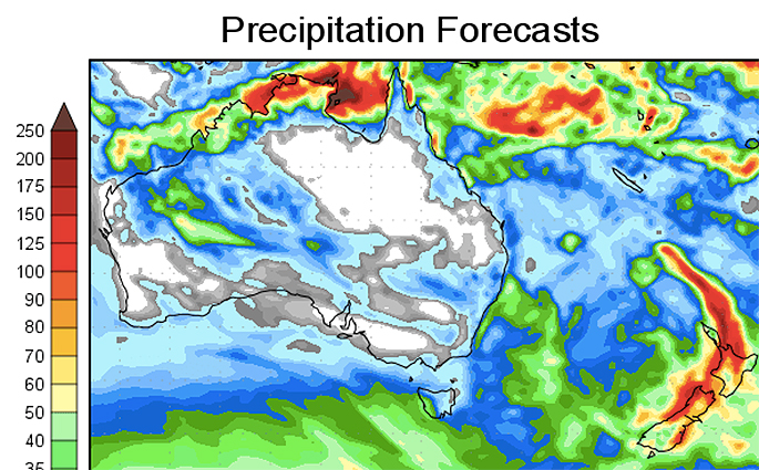 The 7 day rain map gives the clearest indication so far of where the rain will fall and the track Cook will likely take across New Zealand - the red streak from the tropics to Dunedin is the likely track of Cook's remnants/low and rainfall totals look easily to be one or two months worth of rain....yet again. GFS.
There are two lows affecting New Zealand - a large low moving in from the Tasman Sea is today seeing some heavy downpours develop in the upper North Island.
The bridge between this Tasman Low and Cook to the north will likely see a narrow but intense band of rain developing today and becoming heavier on Thursday as Cook approaches.
'To be honest some of the biggest concerns come from the period of time between these lows when that line of very heavy rain forms over Bay of Plenty in particular, but as Cook moves in during Thursday conditons will only get worse before they get better...and then they do get better,” says WeatherWatch.co.nz
'One positive is that Cook looks unlikely to linger - and once it moves through it will sweep up and clear away any of the lingering rain over Bay of Plenty. So while Cook adds to the misery it may also help end the worst of the rain once it zips south.
'Tax funded MetService has issued a number of weather warnings and have a detailed Severe Weather Outlook also. Please stay up to date over the next few days as this complicated system moves down the country.”
The track Cook may take is a very unusual one, potentially crossing over Taupo then sliding down the east coast of the South Island it has the potential to impact most regions and all of our largest cities at some point with a burst of wind and rain. It may not be severe for everyone, but certainly it has the potential to be.
It seems New Zealand has another 'Cook' that wants to trace along our coastline.
General Timings
(these may change by as much as 12 hours) but current modelling suggests the centre of Cook will make landfall on Thursday afternoon or evening around Tauranga area, tracking southwards, maybe even south-west a bit. Yesterday landfall was likely on Friday morning so you can see the timing isn't precisely locked in - but Thursday PM seems most likely based on the data we have at 7amNZT on Wednesday.
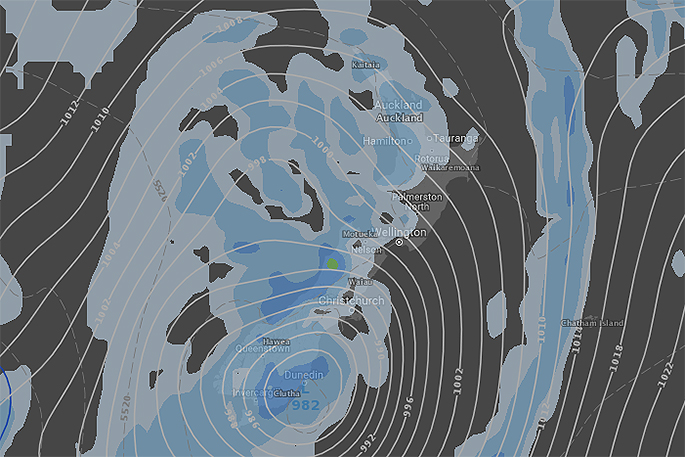
By dawn Friday, the centre of Ex-Cyclone Cook may be close to Christchurch - so it's moving at a good speed but in a very unusual direction down New Zealand. Dunedin should see Cook's remnants move in across Friday with it clearing New Zealand in the early hours of Saturday morning around Stewart Island.
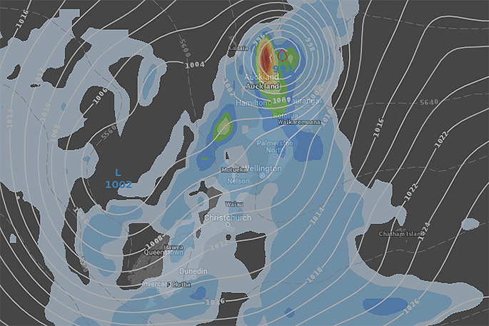 ABOVE - Set up for noon Thursday shows the centre of Cook approaching Coromandel Peninsula/western Bay of Plenty. Both GFS and ECMWF are forecasting a similar location for landfall (at least they were as of 6am Wednesday NZT).
BELOW - Set up for Friday morning shows Cook down near Dunedin now. Please note, the timing and exact track may still change a fair bit so please keep up to date with the Maps here at WeatherWatch.co.nz and the latest MetService warnings.

1 comment
Those poor people
Posted on 12-04-2017 09:21 | By Papamoaner
Their houses are already filled with mud, now it's coming again. Let's hope the stopbank repair holds. The upstream dam is evidently empty now, so hopefully that will help.
Leave a Comment
You must be logged in to make a comment.