Western Bay of Plenty residents are encouraged to have their say on a proposed policy for how the District should tackle the threat of sea level rise and erosion.
Western Bay of Plenty District Council's draft Inner Harbour and Coastal Erosion Management Policy 2017 is open for feedback from 20 February to 20 March.
The draft policy, if adopted, will determine how Council responds to the growing threat of erosion on the District's coastlines and inner harbour margins in the next 30 years.
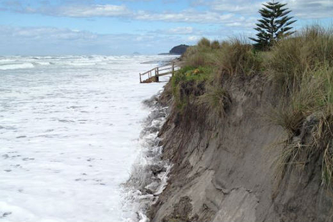
Harbour and coastal erosion happens when wind, waves and water wear away the shore line and contribute to land slips. It is a natural process that is also influenced by human activity.
The nature and rate of erosion along a coastline or harbour is affected by the type of land (e.g. rocky ‘hard' or sandy ‘soft' shores) and the energy of the sea (e.g. a ‘high energy' surf beach or a ‘low energy' sheltered estuary).
New Zealand's sea level has risen about 18cm over the past 100 years. It has also been subjected to coastal storm inundation (flooding) that has been historically documented. This is expected to become more frequent in the future.
Coupled with a predicted further one metre sea level rise, what we currently consider to be an extreme ‘one in 100 year coastal event' – will trend to becoming the norm.
Council's policy and planning manager, Emily Rogers, says the draft policy was created following conversations with the community in 2016 through the ‘Living with the Changing Tides' campaign. It also takes into account all relevant national information and legislation.
'This policy is based on all of the feedback we received last year, as well as the in-depth expert research and detailed projected erosion maps for the District.”
Emily says the draft policy relates only to the future management of Council-owned coastal land and assets – and informs the community of the proposed consistent and precautionary approach.
It limits future Council funding to the protection of Council owned land and strategic assets and states public money will not be spent on the protection of private property.
'From a wider district and long term perspective this makes economic and intergenerational sense. Any public intervention to protect private property on the inner harbour or coast would be at a cost to all ratepayers and a gain only to individual property owners,” says Emily.
Erosion protection works are expensive – with costs such as $3000 per metre for rock revetment walls. The District's inner harbour coastline alone – excluding the margins of Matakana, Rangiwaea and Motuhoa Island – is 140km. If the entire coastline was protected by hard structures the cost could be in excess of $420 million. These works would, in time, likely fail under predicted sea level rise too.
Council is inviting everyone to have their say on what's being proposed, regardless of whether they live by the sea or not.
'It affects you if you use beaches, parks or roads by beaches and may also affect you if you pay rates. Some protection options can be very expensive to construct, maintain and replace. The impact on ratepayers will depend on what options are agreed and how these options are funded.”
Living with the Changing Tides re-opens for feedback on the draft policy on Monday, February 20. It's open until 4pm on Monday, March 20. Visit haveyoursay.westernbay.govt.nz

2 comments
Yeh rite
Posted on 20-02-2017 15:24 | By milka
So the sea level has risen by a 18 cm,and yet at high tide the water on our property still comes in too the same place it did 40 years ago.seems someone has got it wrong !
18cm over the past 100 years.
Posted on 01-03-2017 17:11 | By Capt_Kaveman
180mm show me the proof, sea level has risen about 15mm since about 1940
Leave a Comment
You must be logged in to make a comment.