Maps showing which way to run in the event of a tsunami will be delivered to households along the Mount Maunganui/Papamoa coast next week.
The updated maps are a prompt for residents to get to know where their nearest safe location or zone is and the best route to get there, says Tauranga City Council emergency management manager Paul Brunton.
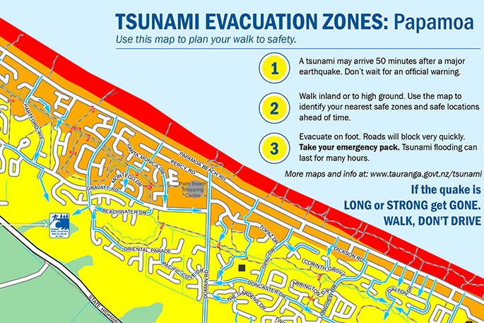
'Use the maps to work out where you need to go to escape a tsunami and practice walking there.”
For Tauranga, the best way to escape from a tsunami is to walk instead of drive.
'There will be crippling traffic jams during an evacuation. Think about what happens to traffic after a concert or a car accident, then magnify that in the aftermath of a big earthquake. You are much better to evacuate by foot or bike.”
Different versions of the tsunami escape maps to be delivered for Mount Maunganui, Bayfair, Papamoa and Papamoa East.
'We've done our best to arrange for each household to receive the map that is most relevant to their area. The other maps are available at the city libraries or online at tauranga.govt.nz/tsunami,” says Paul.
The evacuation maps are based on a 14m tsunami, a wave that rises to 14m above sea level when it reaches the coastline.
This is considered the maximum credible tsunami for the Bay of Plenty region and is generally considered the worst case tsunami or a maximum credible event.
A maximum credible event is a tsunami generated by the largest expected seismic event based on current knowledge and understanding of earthquakes and plate tectonics.
The maximum credible tsunami would be generated by an earthquake somewhere along the Kermadec Trench. The earthquake would need to be greater than magnitude 9 to create a 14m tsunami.
Such and earthquake is predicted to last a long time and be felt very strongly at Tauranga.
Most tsunami scenarios don't come anywhere near the worst case scenario. For instance a tsunami from White Island is unlikely to overtop the dune systems because it simply won't be large enough to do so.
Most tsunami have the potential to pose a marine and beach threat. Some rare tsunami could potentially overtop some of the dune systems along the coastline.
The evacuation maps are based on current best knowledge. This includes in-depth studies undertaken in 2012, 2013, 2014 and 2015 by GNS Science and Tonkin and Taylor.
These studies are peer reviewed by technical experts to ensure they are accurate and utilise the most up to date information and methods of research available. The maps are updated whenever new information comes to hand. The most recent update is December 2016.

3 comments
All good
Posted on 19-01-2017 12:35 | By Papamoaner
All we need now are the sirens to reassure us that it's a real one and the right time to grab and go. That requires someone with the guts to make the decision to press the button. That's what they are all shying away from. I believe they call it bum covering.
Who needs a map!?
Posted on 19-01-2017 14:28 | By Linaire
Omg, looking at that map .. why the heck does anyone need one! Just run as fast as you can INLAND .. and inland is not sideways! Look at the hills behind Papamoa and run as fast as you can to there! What a complete waste of money this stupid map idea is! It would be far better spent on sirens! Words fail me ..
Sirens
Posted on 19-01-2017 17:14 | By Taffy
Just put in the Sirens.Stop pussy footing around.If an event occurs in the middle of the night without sirens you haven,t a hope in hades of escaping.How far can you get on foot in say 30mins you won,t reach high ground,not everyone can run or walk fast.There is only one conclusion the people responsible for this are obviously all down on the beach with their heads in the sand!!!
Leave a Comment
You must be logged in to make a comment.