
It's going to rain, be sunny, and then rain again this week in what Metservice is calling changeable weather, as a series of weather fronts cross over the North Island.
'As well as rain, there is also potential for thunderstorms and hail in some areas due to cold air in the upper atmosphere,” says MetService Meteorologist Stephen Glassey.
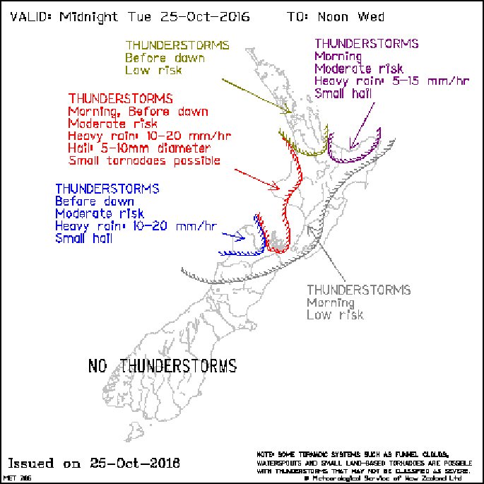
Areas likely to be affected by thunderstorms can be viewed by accessing the latest Thunderstorm Outlook Charts.
Rain or showers is likely to affect most places on Wednesday as a low pressure system moves over central New Zealand.
Thursday is looking dry for most places, apart from a few showers in western areas. However, another rain band moves northeast over the country during Friday and Saturday, followed by a cold southwest change and showers.
'Most people should notice a dip in temperatures this weekend, and there is also potential for snow to affect some higher roads in the South Island,” says Stephen.
A weakening low in the Tasman Sea will move onto central New Zealand around the middle of Wednesday, while associated bands of rain or showers move eastwards across northern and central New Zealand during the morning.
As these bands move across northern and central New Zealand, there is a moderate risk of thunderstorms about western Waitomo, Taranaki, Nelson and northern Marlborough before dawn, then again from mid or late morning.
There is also a moderate risk of thunderstorms about eastern Bay of Plenty mid to late morning. A broad low risk of thunderstorms cover all other North Island and northern South Island areas as indicated on the chart.
These thunderstorms will be accompanied by localised heavy rain and hail. There is also a low risk of one or two small tornadoes about coastal Waitomo, Taranaki and the Marlborough Sounds, however if any tornadoes do occur they will be very localised.
No other thunderstorms or significant convection expected over New Zealand on Wednesday morning.
Keep up to date with the latest forecasts and any watches/warnings at metservice.com or on mobile devices at m.metservice.com.
You can also follow updates on MetService TV, on Facebook, @metservice and @MetServiceWARN on Twitter and at blog.metservice.com

0 comments
Leave a Comment
You must be logged in to make a comment.